Luncile geodata
Luncile (Buzău) is a populated place; located in Romania in Europe/Bucharest (GMT+3) time zone. With population of 974 people, there are 4368 cities with bigger population in this country. Compared to other cities in Romania, 55.4% of cities are located further ↑North; 73.5% of cities are located further ←West and 95.3% of cities have lower elevation than Luncile. Note1


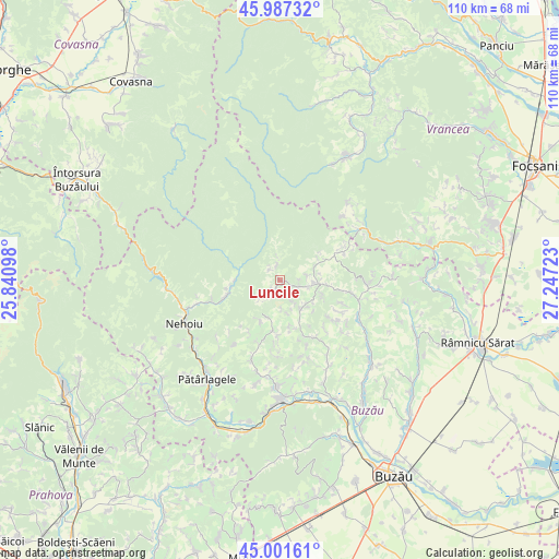
Luncile GPS coordinates[2]
45° 29' 47.832" North, 26° 32' 38.76" East
| Map corner | latitude | longitude |
|---|---|---|
| Upper-left | 45.98732°, | 25.84098° |
| Center: | 45.49662°, | 26.5441° |
| Lower-right: | 45.00161°, | 27.24723° |
| Map W x H: | 109.6×109.6 km | = 68.1×68.1mi |
| max Lat: | 48.23793° ⇑55.4% North |
| Luncile: | 45.49662° |
| min Lat: | ⇓44.6% South 43.65638° |
| min Long | Luncile | max Long |
| 20.31667° | 26.5441° | 29.65403° |
| W 73.5%⇐ | ⇒26.5% E |
Elevation
Elevation of Luncile is 637 m = 2090 ft, and this is 382.1 m = 1254 ft above average elevation for this country.
| Max E: |
1278 m = 4193 ft | 4.7% |
| Luncile | 637 m 2090 ft | |
| Avg. | 254.9 m = 836 ft | |
Min E: |
-2 m = -7 ft | 95.3% |
See also: Romania elevation on elevation.city.
Geographical zone
Luncile is located in North temperate zone (between Tropic of Cancer and the Arctic Circle). Distance of this North polar circle is 2342.4 km =1455.5 mi to North.| Distance of | km | miles | from Luncile |
|---|---|---|---|
| North Pole | 4948.3 | 3074.7 | to North |
| Arctic Circle | 2342.4 | 1455.5 | to North |
| Tropic Cancer | 2452.8 | 1524.1 | to South |
| Equator | 5058.7 | 3143.3 | to South |


Nearby cities:
15 places around Luncile: (largest is in red/bold)
• Brăeşti
7.8 km =4.8 mi,  206°
206°
• Brătilești
5.7 km =3.5 mi,  237°
237°
• Chiliile
6 km =3.7 mi,  149°
149°
• Căneşti
11.6 km =7.2 mi,  157°
157°
• Furtunești
12.1 km =7.5 mi,  250°
250°
• Grunji
8.3 km =5.2 mi,  87°
87°
• Gura Teghii
10 km =6.2 mi,  261°
261°
• Ivănețu
5.8 km =3.6 mi,  224°
224°
• Lopătari
3.4 km =2.1 mi,  115°
115°
• Mânzăleşti
8.3 km =5.2 mi, 87°
• Odăile
12.6 km =7.8 mi,  177°
177°
• Plaiu Nucului
2.3 km =1.4 mi,  225°
225°
• Ploștina
2.9 km =1.8 mi,  315°
315°
• Terca
3.2 km =2 mi,  351°
351°
• Varlaam
7.9 km =4.9 mi,  280°
280°
Sources, notices
• [Note1] Compared only with cities in Romania existing in our database
• [Src1] Map data: © OpenStreetMap contributors (CC-BY-SA)
• [Src2] Other city data from geonames.org with taken over terms of usage.
• [Src3] Geographical zone / Annual Mean Temperature by Robert A. Rohde @ Wikipedia
