Grozeşti geodata
Grozeşti (Mehedinţi) is a seat of a second-order administrative division; located in Romania in Europe/Bucharest (GMT+3) time zone. With population of 2,219 people, there are 2405 cities with bigger population in this country. Compared to other cities in Romania, 81.6% of cities are located further ↑North; 79.7% of cities are located further →East and 56% of cities have lower elevation than Grozeşti. Note1


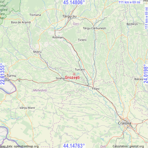
Grozeşti GPS coordinates[2]
44° 39' 0" North, 23° 19' 0.012" East
| Map corner | latitude | longitude |
|---|---|---|
| Upper-left | 45.14806°, | 22.61355° |
| Center: | 44.65°, | 23.31667° |
| Lower-right: | 44.14763°, | 24.0198° |
| Map W x H: | 111.2×111.2 km | = 69.1×69.1mi |
| max Lat: | 48.23793° ⇑81.6% North |
| Grozeşti: | 44.65° |
| min Lat: | ⇓18.4% South 43.65638° |
| min Long | Grozeşti | max Long |
| 20.31667° | 23.31667° | 29.65403° |
| W 20.3%⇐ | ⇒79.7% E |
Elevation
Elevation of Grozeşti is 243 m = 797 ft, and this is 11.9 m = 39 ft below average elevation for this country.
| Max E: |
1278 m = 4193 ft | 44% |
| Avg. | 254.9 m = 836 ft | |
| Grozeşti | 243 m = 797 ft | |
Min E: |
-2 m = -7 ft | 56% |
See also: Romania elevation on elevation.city.
Geographical zone
Grozeşti is located in North temperate zone (between Tropic of Cancer and the Arctic Circle). Distance of this Northern Tropic circle is 2358.7 km =1465.6 mi to South.| Distance of | km | miles | from Grozeşti |
|---|---|---|---|
| North Pole | 5042.4 | 3133.2 | to North |
| Arctic Circle | 2436.6 | 1514 | to North |
| Tropic Cancer | 2358.7 | 1465.6 | to South |
| Equator | 4964.6 | 3084.9 | to South |


Nearby cities:
15 places around Grozeşti: (largest is in red/bold)
• Borăscu
6.2 km =3.9 mi,  334°
334°
• Butoieşti
8.4 km =5.2 mi,  151°
151°
• Calapăru
3.9 km =2.4 mi,  19°
19°
• Cârceni
4.7 km =2.9 mi,  288°
288°
• Iliești
6.8 km =4.2 mi,  96°
96°
• Ioneşti
9.9 km =6.2 mi,  111°
111°
• Izvoarele
9.9 km =6.2 mi,  41°
41°
• Lunca Banului
6.9 km =4.3 mi,  234°
234°
• Menții din Dos
8.7 km =5.4 mi,  302°
302°
• Murgești
7.7 km =4.8 mi,  28°
28°
• Ohaba Jiu
9.6 km =6 mi,  324°
324°
• Pluta
8.4 km =5.2 mi,  172°
172°
• Strehaia
9.9 km =6.2 mi,  248°
248°
• Stângăceaua
4.6 km =2.9 mi,  183°
183°
• Turceni
5.4 km =3.4 mi,  46°
46°
Sources, notices
• [Note1] Compared only with cities in Romania existing in our database
• [Src1] Map data: © OpenStreetMap contributors (CC-BY-SA)
• [Src2] Other city data from geonames.org with taken over terms of usage.
• [Src3] Geographical zone / Annual Mean Temperature by Robert A. Rohde @ Wikipedia
