Groşi geodata
Groşi (Maramureş) is a seat of a second-order administrative division; located in Romania in Europe/Bucharest (GMT+3) time zone. With population of 2,493 people, there are 2166 cities with bigger population in this country. Compared to other cities in Romania, 93.3% of cities are located further ↓South; 75.4% of cities are located further →East and 54.4% of cities have lower elevation than Groşi. Note1


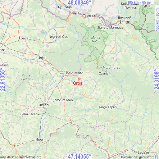
Groşi GPS coordinates[2]
47° 37' 0.012" North, 23° 37' 0.012" East
| Map corner | latitude | longitude |
|---|---|---|
| Upper-left | 48.08849°, | 22.91355° |
| Center: | 47.61667°, | 23.61667° |
| Lower-right: | 47.14055°, | 24.3198° |
| Map W x H: | 105.4×105.4 km | = 65.5×65.5mi |
| max Lat: | 48.23793° ⇑6.7% North |
| Groşi: | 47.61667° |
| min Lat: | ⇓93.3% South 43.65638° |
| min Long | Groşi | max Long |
| 20.31667° | 23.61667° | 29.65403° |
| W 24.6%⇐ | ⇒75.4% E |
Elevation
Elevation of Groşi is 235 m = 771 ft, and this is 19.9 m = 65 ft below average elevation for this country.
| Max E: |
1278 m = 4193 ft | 45.6% |
| Avg. | 254.9 m = 836 ft | |
| Groşi | 235 m = 771 ft | |
Min E: |
-2 m = -7 ft | 54.4% |
See also: Romania elevation on elevation.city.
Geographical zone
Groşi is located in North temperate zone (between Tropic of Cancer and the Arctic Circle). Distance of this North polar circle is 2106.7 km =1309 mi to North.| Distance of | km | miles | from Groşi |
|---|---|---|---|
| North Pole | 4712.6 | 2928.3 | to North |
| Arctic Circle | 2106.7 | 1309 | to North |
| Tropic Cancer | 2688.6 | 1670.6 | to South |
| Equator | 5294.5 | 3289.8 | to South |


Nearby cities:
15 places around Groşi: (largest is in red/bold)
• Baia Mare
5.8 km =3.6 mi,  321°
321°
• Baia Sprie
7.6 km =4.7 mi,  48°
48°
• Chechiș
3.7 km =2.3 mi,  194°
194°
• Coltău
7.2 km =4.5 mi,  253°
253°
• Coruia
6.1 km =3.8 mi, 194°
• Culcea
7.3 km =4.5 mi,  219°
219°
• Cărbunari
5.1 km =3.2 mi,  156°
156°
• Dumbrăviţa
3.1 km =1.9 mi,  126°
126°
• Mocira
6.9 km =4.3 mi,  275°
275°
• Rus
4 km =2.5 mi,  96°
96°
• Satu Nou de Jos
3.6 km =2.2 mi,  269°
269°
• Săcălășeni
5.5 km =3.4 mi,  225°
225°
• Tăuții de Sus
5.4 km =3.4 mi,  35°
35°
• Șindrești
6 km =3.7 mi, 100°
• Șisești
7.1 km =4.4 mi,  73°
73°
Sources, notices
• [Note1] Compared only with cities in Romania existing in our database
• [Src1] Map data: © OpenStreetMap contributors (CC-BY-SA)
• [Src2] Other city data from geonames.org with taken over terms of usage.
• [Src3] Geographical zone / Annual Mean Temperature by Robert A. Rohde @ Wikipedia
