Grăniceri geodata
Grăniceri (Arad) is a seat of a second-order administrative division; located in Romania in Europe/Bucharest (GMT+3) time zone. With population of 2,547 people, there are 2116 cities with bigger population in this country. Compared to other cities in Romania, 67.4% of cities are located further ↓South; 98.4% of cities are located further →East and 80.8% of cities have higher elevation than Grăniceri. Note1


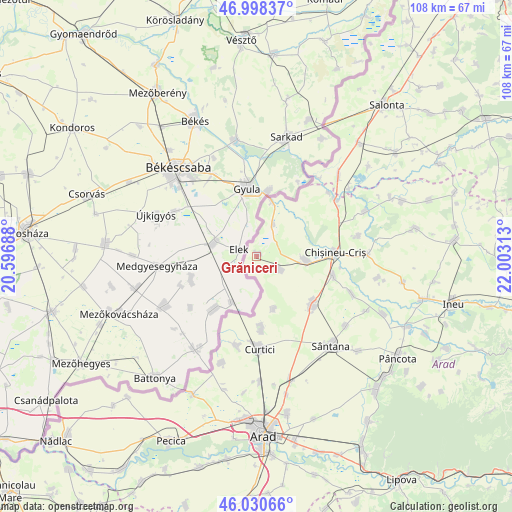
Grăniceri GPS coordinates[2]
46° 31' 0.012" North, 21° 18' 0" East
| Map corner | latitude | longitude |
|---|---|---|
| Upper-left | 46.99837°, | 20.59688° |
| Center: | 46.51667°, | 21.3° |
| Lower-right: | 46.03066°, | 22.00313° |
| Map W x H: | 107.6×107.6 km | = 66.9×66.9mi |
| max Lat: | 48.23793° ⇑32.6% North |
| Grăniceri: | 46.51667° |
| min Lat: | ⇓67.4% South 43.65638° |
| min Long | Grăniceri | max Long |
| 20.31667° | 21.3° | 29.65403° |
| W 1.6%⇐ | ⇒98.4% E |
Elevation
Elevation of Grăniceri is 92 m = 302 ft, and this is 162.9 m = 534 ft below average elevation for this country.
| Max E: |
1278 m = 4193 ft | 80.8% |
| Avg. | 254.9 m = 836 ft | |
| Grăniceri | 92 m = 302 ft | |
Min E: |
-2 m = -7 ft | 19.2% |
See also: Romania elevation on elevation.city.
Geographical zone
Grăniceri is located in North temperate zone (between Tropic of Cancer and the Arctic Circle). Distance of this North polar circle is 2229 km =1385 mi to North.| Distance of | km | miles | from Grăniceri |
|---|---|---|---|
| North Pole | 4834.9 | 3004.3 | to North |
| Arctic Circle | 2229 | 1385 | to North |
| Tropic Cancer | 2566.2 | 1594.6 | to South |
| Equator | 5172.2 | 3213.9 | to South |


Nearby cities:
15 places around Grăniceri: (largest is in red/bold)
• Adea
22.2 km =13.8 mi,  78°
78°
• Chişineu-Criş
16.7 km =10.4 mi,  86°
86°
• Cintei
21.9 km =13.6 mi,  111°
111°
• Curtici
18.5 km =11.5 mi,  180°
180°
• Dorobanți
19 km =11.8 mi,  192°
192°
• Iermata Neagră
20.3 km =12.6 mi,  48°
48°
• Macea
14.8 km =9.2 mi, 180°
• Nadab
16.7 km =10.4 mi,  103°
103°
• Pilu
6.7 km =4.2 mi,  34°
34°
• Socodor
10.2 km =6.3 mi, 90°
• Sânmartin
11.7 km =7.3 mi,  161°
161°
• Vărșand
11.8 km =7.3 mi,  16°
16°
• Zerind
19.9 km =12.4 mi,  56°
56°
• Şimand
14.8 km =9.2 mi,  128°
128°
• Șiclău
5.9 km =3.7 mi,  118°
118°
Sources, notices
• [Note1] Compared only with cities in Romania existing in our database
• [Src1] Map data: © OpenStreetMap contributors (CC-BY-SA)
• [Src2] Other city data from geonames.org with taken over terms of usage.
• [Src3] Geographical zone / Annual Mean Temperature by Robert A. Rohde @ Wikipedia
