Dorobanți geodata
Dorobanți (Arad) is a seat of a second-order administrative division; located in Romania in Europe/Bucharest (GMT+3) time zone. With population of 1,841 people, there are 2772 cities with bigger population in this country. Compared to other cities in Romania, 63.5% of cities are located further ↓South; 98.5% of cities are located further →East and 78.4% of cities have higher elevation than Dorobanți. Note1


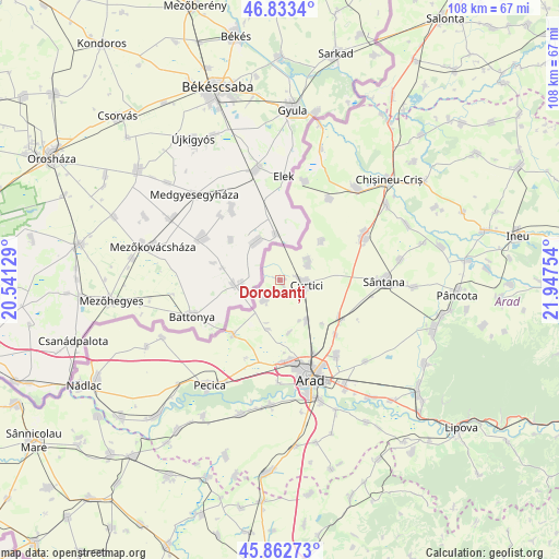
Dorobanți GPS coordinates[2]
46° 21' 0.792" North, 21° 14' 39.876" East
| Map corner | latitude | longitude |
|---|---|---|
| Upper-left | 46.8334°, | 20.54129° |
| Center: | 46.35022°, | 21.24441° |
| Lower-right: | 45.86273°, | 21.94754° |
| Map W x H: | 107.9×107.9 km | = 67×67mi |
| max Lat: | 48.23793° ⇑36.5% North |
| Dorobanți: | 46.35022° |
| min Lat: | ⇓63.5% South 43.65638° |
| min Long | Dorobanți | max Long |
| 20.31667° | 21.24441° | 29.65403° |
| W 1.5%⇐ | ⇒98.5% E |
Elevation
Elevation of Dorobanți is 100 m = 328 ft, and this is 154.9 m = 508 ft below average elevation for this country.
| Max E: |
1278 m = 4193 ft | 78.4% |
| Avg. | 254.9 m = 836 ft | |
| Dorobanți | 100 m = 328 ft | |
Min E: |
-2 m = -7 ft | 21.6% |
See also: Romania elevation on elevation.city.
Geographical zone
Dorobanți is located in North temperate zone (between Tropic of Cancer and the Arctic Circle). Distance of this North polar circle is 2247.5 km =1396.5 mi to North.| Distance of | km | miles | from Dorobanți |
|---|---|---|---|
| North Pole | 4853.4 | 3015.8 | to North |
| Arctic Circle | 2247.5 | 1396.5 | to North |
| Tropic Cancer | 2547.7 | 1583.1 | to South |
| Equator | 5153.7 | 3202.4 | to South |


Nearby cities:
15 places around Dorobanți: (largest is in red/bold)
• Andrei Șaguna
13.3 km =8.3 mi,  121°
121°
• Arad
19.4 km =12.1 mi,  163°
163°
• Curtici
4.3 km =2.7 mi,  90°
90°
• Grăniceri
19 km =11.8 mi,  12°
12°
• Iratoşu
5.1 km =3.2 mi,  222°
222°
• Livada
17.8 km =11.1 mi,  142°
142°
• Macea
5.6 km =3.5 mi,  49°
49°
• Sânmartin
10.9 km =6.8 mi, 47°
• Sânpaul
10.4 km =6.5 mi,  169°
169°
• Sântana
19.6 km =12.2 mi, 90°
• Turnu
13.7 km =8.5 mi, 221°
• Zimandu Nou
14.1 km =8.8 mi, 121°
• Şimand
18.3 km =11.4 mi,  59°
59°
• Şofronea
10.2 km =6.3 mi, 155°
• Șiclău
18.3 km =11.4 mi,  31°
31°
Sources, notices
• [Note1] Compared only with cities in Romania existing in our database
• [Src1] Map data: © OpenStreetMap contributors (CC-BY-SA)
• [Src2] Other city data from geonames.org with taken over terms of usage.
• [Src3] Geographical zone / Annual Mean Temperature by Robert A. Rohde @ Wikipedia
