Giurgeni geodata
Giurgeni (Neamţ) is a populated place; located in Romania in Europe/Bucharest (GMT+3) time zone. With population of 760 people, there are 5241 cities with bigger population in this country. Compared to other cities in Romania, 74.5% of cities are located further ↓South; 85.4% of cities are located further ←West and 68.3% of cities have lower elevation than Giurgeni. Note1


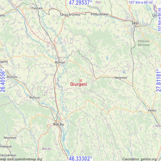
Giurgeni GPS coordinates[2]
46° 48' 58.86" North, 27° 6' 31.248" East
| Map corner | latitude | longitude |
|---|---|---|
| Upper-left | 47.29537°, | 26.40556° |
| Center: | 46.81635°, | 27.10868° |
| Lower-right: | 46.33302°, | 27.81181° |
| Map W x H: | 107×107 km | = 66.5×66.5mi |
| max Lat: | 48.23793° ⇑25.5% North |
| Giurgeni: | 46.81635° |
| min Lat: | ⇓74.5% South 43.65638° |
| min Long | Giurgeni | max Long |
| 20.31667° | 27.10868° | 29.65403° |
| W 85.4%⇐ | ⇒14.6% E |
Elevation
Elevation of Giurgeni is 308 m = 1010 ft, and this is 53.1 m = 174 ft above average elevation for this country.
| Max E: |
1278 m = 4193 ft | 31.7% |
| Giurgeni | 308 m 1010 ft | |
| Avg. | 254.9 m = 836 ft | |
Min E: |
-2 m = -7 ft | 68.3% |
See also: Romania elevation on elevation.city.
Geographical zone
Giurgeni is located in North temperate zone (between Tropic of Cancer and the Arctic Circle). Distance of this North polar circle is 2195.7 km =1364.3 mi to North.| Distance of | km | miles | from Giurgeni |
|---|---|---|---|
| North Pole | 4801.6 | 2983.6 | to North |
| Arctic Circle | 2195.7 | 1364.3 | to North |
| Tropic Cancer | 2599.6 | 1615.3 | to South |
| Equator | 5205.5 | 3234.5 | to South |


Nearby cities:
15 places around Giurgeni: (largest is in red/bold)
• Averești
8.2 km =5.1 mi,  320°
320°
• Bozieni
3.7 km =2.3 mi,  59°
59°
• Bucium
5.1 km =3.2 mi,  213°
213°
• Băceşti
10.2 km =6.3 mi,  68°
68°
• Bălușești
8.4 km =5.2 mi,  269°
269°
• Chilii
5.9 km =3.7 mi,  254°
254°
• Cuci
6.9 km =4.3 mi,  79°
79°
• Călugăreni
10.3 km =6.4 mi,  219°
219°
• Mâlosu
10.1 km =6.3 mi,  149°
149°
• Oniceni
3.1 km =1.9 mi,  89°
89°
• Poienari
8.1 km =5 mi,  10°
10°
• Pânceşti
10.2 km =6.3 mi,  19°
19°
• Solca
7.2 km =4.5 mi, 149°
• Stejaru
5.6 km =3.5 mi,  307°
307°
• Valea Ursului
1.9 km =1.2 mi, 271°
Sources, notices
• [Note1] Compared only with cities in Romania existing in our database
• [Src1] Map data: © OpenStreetMap contributors (CC-BY-SA)
• [Src2] Other city data from geonames.org with taken over terms of usage.
• [Src3] Geographical zone / Annual Mean Temperature by Robert A. Rohde @ Wikipedia
