Călugăreni geodata
Călugăreni (Bacău) is a populated place; located in Romania in Europe/Bucharest (GMT+3) time zone. With population of 833 people, there are 4911 cities with bigger population in this country. Compared to other cities in Romania, 72.7% of cities are located further ↓South; 83.3% of cities are located further ←West and 51.5% of cities have lower elevation than Călugăreni. Note1


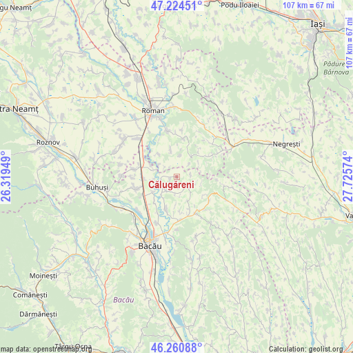
Călugăreni GPS coordinates[2]
46° 44' 41.46" North, 27° 1' 21.396" East
| Map corner | latitude | longitude |
|---|---|---|
| Upper-left | 47.22451°, | 26.31949° |
| Center: | 46.74485°, | 27.02261° |
| Lower-right: | 46.26088°, | 27.72574° |
| Map W x H: | 107.1×107.1 km | = 66.5×66.5mi |
| max Lat: | 48.23793° ⇑27.3% North |
| Călugăreni: | 46.74485° |
| min Lat: | ⇓72.7% South 43.65638° |
| min Long | Călugăreni | max Long |
| 20.31667° | 27.02261° | 29.65403° |
| W 83.3%⇐ | ⇒16.7% E |
Elevation
Elevation of Călugăreni is 219 m = 719 ft, and this is 35.9 m = 118 ft below average elevation for this country.
| Max E: |
1278 m = 4193 ft | 48.5% |
| Avg. | 254.9 m = 836 ft | |
| Călugăreni | 219 m = 719 ft | |
Min E: |
-2 m = -7 ft | 51.5% |
See also: Romania elevation on elevation.city.
Geographical zone
Călugăreni is located in North temperate zone (between Tropic of Cancer and the Arctic Circle). Distance of this North polar circle is 2203.6 km =1369.3 mi to North.| Distance of | km | miles | from Călugăreni |
|---|---|---|---|
| North Pole | 4809.5 | 2988.5 | to North |
| Arctic Circle | 2203.6 | 1369.3 | to North |
| Tropic Cancer | 2591.6 | 1610.3 | to South |
| Equator | 5197.5 | 3229.6 | to South |


Nearby cities:
15 places around Călugăreni: (largest is in red/bold)
• Bogdănești
8.8 km =5.5 mi,  183°
183°
• Bucium
5.3 km =3.3 mi,  44°
44°
• Bălușești
8.1 km =5 mi,  347°
347°
• Chilii
6.5 km =4 mi,  7°
7°
• Ciuturești
9.7 km =6 mi,  127°
127°
• Dămieneşti
3.3 km =2.1 mi,  246°
246°
• Filipeşti
10.6 km =6.6 mi,  273°
273°
• Giurgeni
10.3 km =6.4 mi, 39°
• Icuseşti
9.2 km =5.7 mi,  312°
312°
• Negri
6.6 km =4.1 mi,  220°
220°
• Poiana
5.2 km =3.2 mi, 184°
• Prăjești
10.6 km =6.6 mi,  199°
199°
• Roşiori
5.6 km =3.5 mi,  124°
124°
• Solca
10.3 km =6.4 mi,  80°
80°
• Valea Ursului
9.2 km =5.7 mi,  30°
30°
Sources, notices
• [Note1] Compared only with cities in Romania existing in our database
• [Src1] Map data: © OpenStreetMap contributors (CC-BY-SA)
• [Src2] Other city data from geonames.org with taken over terms of usage.
• [Src3] Geographical zone / Annual Mean Temperature by Robert A. Rohde @ Wikipedia
