Giurgeni geodata
Giurgeni (Ialomiţa) is a seat of a second-order administrative division; located in Romania in Europe/Bucharest (GMT+3) time zone. With population of 1,629 people, there are 3004 cities with bigger population in this country. Compared to other cities in Romania, 77.9% of cities are located further ↑North; 95.2% of cities are located further ←West and 99.7% of cities have higher elevation than Giurgeni. Note1


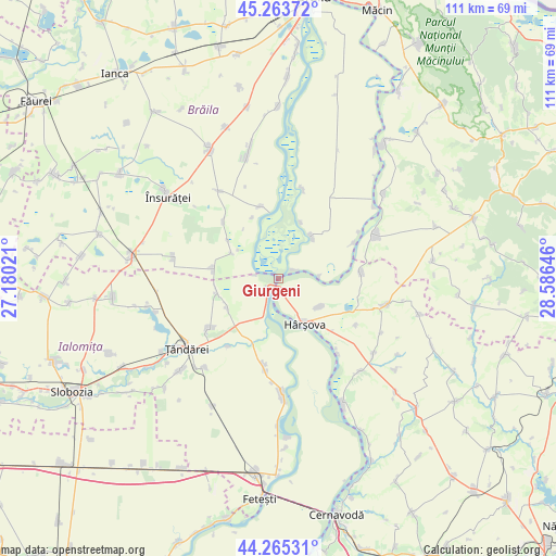
Giurgeni GPS coordinates[2]
44° 46' 0.012" North, 27° 52' 59.988" East
| Map corner | latitude | longitude |
|---|---|---|
| Upper-left | 45.26372°, | 27.18021° |
| Center: | 44.76667°, | 27.88333° |
| Lower-right: | 44.26531°, | 28.58646° |
| Map W x H: | 111×111 km | = 69×69mi |
| max Lat: | 48.23793° ⇑77.9% North |
| Giurgeni: | 44.76667° |
| min Lat: | ⇓22.1% South 43.65638° |
| min Long | Giurgeni | max Long |
| 20.31667° | 27.88333° | 29.65403° |
| W 95.2%⇐ | ⇒4.8% E |
Elevation
Elevation of Giurgeni is 4 m = 13 ft, and this is 250.9 m = 823 ft below average elevation for this country.
| Max E: |
1278 m = 4193 ft | 99.7% |
| Avg. | 254.9 m = 836 ft | |
| Giurgeni | 4 m = 13 ft | |
Min E: |
-2 m = -7 ft | 0.3% |
See also: Romania elevation on elevation.city.
Geographical zone
Giurgeni is located in North temperate zone (between Tropic of Cancer and the Arctic Circle). Distance of this Northern Tropic circle is 2371.7 km =1473.7 mi to South.| Distance of | km | miles | from Giurgeni |
|---|---|---|---|
| North Pole | 5029.5 | 3125.2 | to North |
| Arctic Circle | 2423.6 | 1506 | to North |
| Tropic Cancer | 2371.7 | 1473.7 | to South |
| Equator | 4977.6 | 3092.9 | to South |


Nearby cities:
15 places around Giurgeni: (largest is in red/bold)
• Agaua
17 km =10.6 mi,  63°
63°
• Berteştii de Jos
12.9 km =8 mi,  305°
305°
• Băndoiu
12 km =7.5 mi,  22°
22°
• Ciobanu
9.8 km =6.1 mi,  123°
123°
• Gura Ialomiței
11.7 km =7.3 mi,  241°
241°
• Gârliciu
15.8 km =9.8 mi,  90°
90°
• Hârşova
10.4 km =6.5 mi,  149°
149°
• Luciu
12.5 km =7.8 mi,  260°
260°
• Mihai Bravu
12.9 km =8 mi,  278°
278°
• Mihail Kogălniceanu
15 km =9.3 mi,  231°
231°
• Măgureni
3.8 km =2.4 mi, 61°
• Măraşu
11.4 km =7.1 mi,  35°
35°
• Spiru Haret
15.6 km =9.7 mi,  315°
315°
• Stăncuţa
15.3 km =9.5 mi,  345°
345°
• Vlădeni
16.7 km =10.4 mi,  180°
180°
Sources, notices
• [Note1] Compared only with cities in Romania existing in our database
• [Src1] Map data: © OpenStreetMap contributors (CC-BY-SA)
• [Src2] Other city data from geonames.org with taken over terms of usage.
• [Src3] Geographical zone / Annual Mean Temperature by Robert A. Rohde @ Wikipedia
