Hârşova geodata
Hârşova (Constanța) is a seat of a second-order administrative division; located in Romania in Europe/Bucharest (GMT+3) time zone. With population of 10,055 people, there are 215 cities with bigger population in this country. Compared to other cities in Romania, 80.4% of cities are located further ↑North; 95.9% of cities are located further ←West and 99.8% of cities have higher elevation than Hârşova. Note1


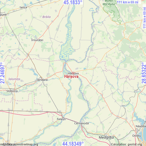
Hârşova GPS coordinates[2]
44° 41' 7.98" North, 27° 57' 0.324" East
| Map corner | latitude | longitude |
|---|---|---|
| Upper-left | 45.1833°, | 27.24697° |
| Center: | 44.68555°, | 27.95009° |
| Lower-right: | 44.18349°, | 28.65322° |
| Map W x H: | 111.2×111.2 km | = 69.1×69.1mi |
| max Lat: | 48.23793° ⇑80.4% North |
| Hârşova: | 44.68555° |
| min Lat: | ⇓19.6% South 43.65638° |
| min Long | Hârşova | max Long |
| 20.31667° | 27.95009° | 29.65403° |
| W 95.9%⇐ | ⇒4.1% E |
Elevation
Elevation of Hârşova is 3 m = 10 ft, and this is 251.9 m = 826 ft below average elevation for this country.
| Max E: |
1278 m = 4193 ft | 99.8% |
| Avg. | 254.9 m = 836 ft | |
| Hârşova | 3 m = 10 ft | |
Min E: |
-2 m = -7 ft | 0.2% |
See also: Romania elevation on elevation.city.
Geographical zone
Hârşova is located in North temperate zone (between Tropic of Cancer and the Arctic Circle). Distance of this Northern Tropic circle is 2362.6 km =1468.1 mi to South.| Distance of | km | miles | from Hârşova |
|---|---|---|---|
| North Pole | 5038.5 | 3130.8 | to North |
| Arctic Circle | 2432.6 | 1511.5 | to North |
| Tropic Cancer | 2362.6 | 1468.1 | to South |
| Equator | 4968.6 | 3087.3 | to South |


Nearby cities:
15 places around Hârşova: (largest is in red/bold)
• Ciobanu
4.6 km =2.9 mi,  39°
39°
• Făcăeni
13.8 km =8.6 mi,  196°
196°
• Ghindăreşti
7.7 km =4.8 mi,  120°
120°
• Giurgeni
10.4 km =6.5 mi,  329°
329°
• Gura Ialomiței
15.9 km =9.9 mi,  282°
282°
• Gârliciu
13.9 km =8.6 mi,  49°
49°
• Horia
14.4 km =8.9 mi,  113°
113°
• Luciu
18.9 km =11.7 mi,  291°
291°
• Mihail Kogălniceanu
17.1 km =10.6 mi,  269°
269°
• Măgureni
11 km =6.8 mi,  350°
350°
• Măraşu
18.3 km =11.4 mi,  4°
4°
• Progresu
13.4 km =8.3 mi,  208°
208°
• Saraiu
16.2 km =10.1 mi,  77°
77°
• Topalu
17.5 km =10.9 mi,  154°
154°
• Vlădeni
9.3 km =5.8 mi, 214°
Sources, notices
• [Note1] Compared only with cities in Romania existing in our database
• [Src1] Map data: © OpenStreetMap contributors (CC-BY-SA)
• [Src2] Other city data from geonames.org with taken over terms of usage.
• [Src3] Geographical zone / Annual Mean Temperature by Robert A. Rohde @ Wikipedia
