Ghimpați geodata
Ghimpați (Dâmboviţa) is a populated place; located in Romania in Europe/Bucharest (GMT+3) time zone. With population of 983 people, there are 4346 cities with bigger population in this country. Compared to other cities in Romania, 81.3% of cities are located further ↑North; 59% of cities are located further ←West and 68.7% of cities have higher elevation than Ghimpați. Note1


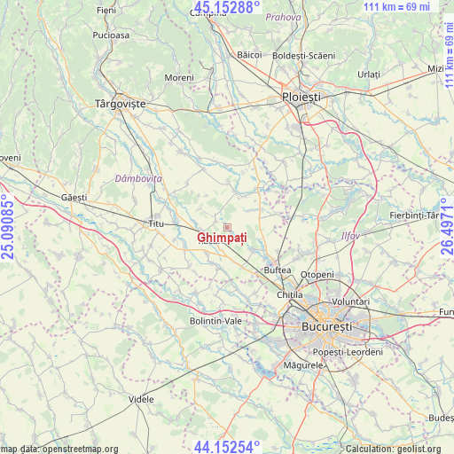
Ghimpați GPS coordinates[2]
44° 39' 17.532" North, 25° 47' 38.292" East
| Map corner | latitude | longitude |
|---|---|---|
| Upper-left | 45.15288°, | 25.09085° |
| Center: | 44.65487°, | 25.79397° |
| Lower-right: | 44.15254°, | 26.4971° |
| Map W x H: | 111.2×111.2 km | = 69.1×69.1mi |
| max Lat: | 48.23793° ⇑81.3% North |
| Ghimpați: | 44.65487° |
| min Lat: | ⇓18.7% South 43.65638° |
| min Long | Ghimpați | max Long |
| 20.31667° | 25.79397° | 29.65403° |
| W 59%⇐ | ⇒41% E |
Elevation
Elevation of Ghimpați is 132 m = 433 ft, and this is 122.9 m = 403 ft below average elevation for this country.
| Max E: |
1278 m = 4193 ft | 68.7% |
| Avg. | 254.9 m = 836 ft | |
| Ghimpați | 132 m = 433 ft | |
Min E: |
-2 m = -7 ft | 31.3% |
See also: Romania elevation on elevation.city.
Geographical zone
Ghimpați is located in North temperate zone (between Tropic of Cancer and the Arctic Circle). Distance of this Northern Tropic circle is 2359.2 km =1465.9 mi to South.| Distance of | km | miles | from Ghimpați |
|---|---|---|---|
| North Pole | 5041.9 | 3132.9 | to North |
| Arctic Circle | 2436 | 1513.7 | to North |
| Tropic Cancer | 2359.2 | 1465.9 | to South |
| Equator | 4965.2 | 3085.2 | to South |


Nearby cities:
15 places around Ghimpați: (largest is in red/bold)
• Bâldana
5.9 km =3.7 mi,  192°
192°
• Bălteni
8 km =5 mi,  277°
277°
• Ciocăneşti
7.5 km =4.7 mi,  143°
143°
• Cocani
8.5 km =5.3 mi,  110°
110°
• Cojasca
8.2 km =5.1 mi,  32°
32°
• Colacu
3.2 km =2 mi,  299°
299°
• Crețu
4.4 km =2.7 mi, 139°
• Decindea
8.4 km =5.2 mi, 136°
• Ghergani
6 km =3.7 mi,  249°
249°
• Iazu
7.6 km =4.7 mi,  22°
22°
• Mavrodin
6.1 km =3.8 mi,  264°
264°
• Răcari
5.4 km =3.4 mi,  243°
243°
• Săbiești
4.2 km =2.6 mi,  318°
318°
• Urziceanca
4.7 km =2.9 mi,  125°
125°
• Vizurești
1.9 km =1.2 mi,  146°
146°
Sources, notices
• [Note1] Compared only with cities in Romania existing in our database
• [Src1] Map data: © OpenStreetMap contributors (CC-BY-SA)
• [Src2] Other city data from geonames.org with taken over terms of usage.
• [Src3] Geographical zone / Annual Mean Temperature by Robert A. Rohde @ Wikipedia
