Cocani geodata
Cocani (Dâmboviţa) is a populated place; located in Romania in Europe/Bucharest (GMT+3) time zone. With population of 585 people, there are 6325 cities with bigger population in this country. Compared to other cities in Romania, 82% of cities are located further ↑North; 61% of cities are located further ←West and 73.6% of cities have higher elevation than Cocani. Note1


Cocani GPS coordinates[2]
44° 37' 42.996" North, 25° 53' 42.036" East
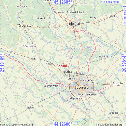
| Map corner | latitude | longitude |
|---|---|---|
| Upper-left | 45.12685°, | 25.19189° |
| Center: | 44.62861°, | 25.89501° |
| Lower-right: | 44.12606°, | 26.59814° |
| Map W x H: | 111.3×111.3 km | = 69.2×69.2mi |
| max Lat: | 48.23793° ⇑82% North |
| Cocani: | 44.62861° |
| min Lat: | ⇓18% South 43.65638° |
| min Long | Cocani | max Long |
| 20.31667° | 25.89501° | 29.65403° |
| W 61%⇐ | ⇒39% E |
Elevation
Elevation of Cocani is 115 m = 377 ft, and this is 139.9 m = 459 ft below average elevation for this country.
| Max E: |
1278 m = 4193 ft | 73.6% |
| Avg. | 254.9 m = 836 ft | |
| Cocani | 115 m = 377 ft | |
Min E: |
-2 m = -7 ft | 26.4% |
See also: Romania elevation on elevation.city.
Geographical zone
Cocani is located in North temperate zone (between Tropic of Cancer and the Arctic Circle). Distance of this Northern Tropic circle is 2356.3 km =1464.1 mi to South.| Distance of | km | miles | from Cocani |
|---|---|---|---|
| North Pole | 5044.8 | 3134.7 | to North |
| Arctic Circle | 2438.9 | 1515.5 | to North |
| Tropic Cancer | 2356.3 | 1464.1 | to South |
| Equator | 4962.2 | 3083.4 | to South |


Nearby cities:
15 places around Cocani: (largest is in red/bold)
• Buftea
8.6 km =5.3 mi,  150°
150°
• Butimanu
6.1 km =3.8 mi,  3°
3°
• Ciocăneşti
4.8 km =3 mi,  228°
228°
• Crevedia
4.4 km =2.7 mi,  136°
136°
• Crețu
5.2 km =3.2 mi,  265°
265°
• Decindea
3.9 km =2.4 mi,  215°
215°
• Dârza
5.2 km =3.2 mi,  124°
124°
• Ghimpați
8.5 km =5.3 mi,  290°
290°
• Movila
8.3 km =5.2 mi,  46°
46°
• Mânăstirea
5.9 km =3.7 mi, 151°
• Niculești
7.1 km =4.4 mi,  31°
31°
• Samurcași
6.2 km =3.9 mi,  161°
161°
• Tărtăşeşti
8.7 km =5.4 mi, 228°
• Urziceanca
4.2 km =2.6 mi, 272°
• Vizurești
7.1 km =4.4 mi,  280°
280°
Sources, notices
• [Note1] Compared only with cities in Romania existing in our database
• [Src1] Map data: © OpenStreetMap contributors (CC-BY-SA)
• [Src2] Other city data from geonames.org with taken over terms of usage.
• [Src3] Geographical zone / Annual Mean Temperature by Robert A. Rohde @ Wikipedia
