Gălăuţaş geodata
Gălăuţaş (Harghita) is a seat of a second-order administrative division; located in Romania in Europe/Bucharest (GMT+3) time zone. With population of 2,618 people, there are 2047 cities with bigger population in this country. Compared to other cities in Romania, 76.7% of cities are located further ↓South; 53.4% of cities are located further ←West and 98.9% of cities have lower elevation than Gălăuţaş. Note1


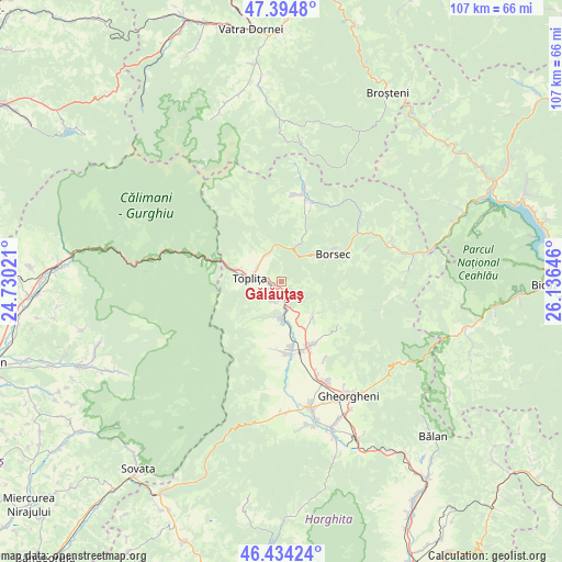
Gălăuţaş GPS coordinates[2]
46° 55' 0.012" North, 25° 25' 59.988" East
| Map corner | latitude | longitude |
|---|---|---|
| Upper-left | 47.3948°, | 24.73021° |
| Center: | 46.91667°, | 25.43333° |
| Lower-right: | 46.43424°, | 26.13646° |
| Map W x H: | 106.8×106.8 km | = 66.4×66.4mi |
| max Lat: | 48.23793° ⇑23.3% North |
| Gălăuţaş: | 46.91667° |
| min Lat: | ⇓76.7% South 43.65638° |
| min Long | Gălăuţaş | max Long |
| 20.31667° | 25.43333° | 29.65403° |
| W 53.4%⇐ | ⇒46.6% E |
Elevation
Elevation of Gălăuţaş is 846 m = 2776 ft, and this is 591.1 m = 1939 ft above average elevation for this country.
| Max E: |
1278 m = 4193 ft | 1.1% |
| Gălăuţaş | 846 m 2776 ft | |
| Avg. | 254.9 m = 836 ft | |
Min E: |
-2 m = -7 ft | 98.9% |
See also: Romania elevation on elevation.city.
Geographical zone
Gălăuţaş is located in North temperate zone (between Tropic of Cancer and the Arctic Circle). Distance of this North polar circle is 2184.5 km =1357.4 mi to North.| Distance of | km | miles | from Gălăuţaş |
|---|---|---|---|
| North Pole | 4790.4 | 2976.6 | to North |
| Arctic Circle | 2184.5 | 1357.4 | to North |
| Tropic Cancer | 2610.7 | 1622.2 | to South |
| Equator | 5216.6 | 3241.4 | to South |


Nearby cities:
15 places around Gălăuţaş: (largest is in red/bold)
• Borsec
10.8 km =6.7 mi,  69°
69°
• Călimănel
9 km =5.6 mi,  286°
286°
• Ditrău
12.8 km =8 mi,  150°
150°
• Fundoaia
3.5 km =2.2 mi, 145°
• Hodoșa
5.8 km =3.6 mi,  170°
170°
• Jolotca
9.3 km =5.8 mi,  129°
129°
• Moglănești
3.9 km =2.4 mi,  281°
281°
• Măgheruș
6.6 km =4.1 mi,  273°
273°
• Platonești
2.9 km =1.8 mi, 166°
• Remetea
14.9 km =9.3 mi,  175°
175°
• Runc
1.3 km =0.8 mi,  236°
236°
• Subcetate
7.5 km =4.7 mi, 170°
• Sărmaş
4.5 km =2.8 mi, 145°
• Vale
5.5 km =3.4 mi,  310°
310°
• Zencani
7.6 km =4.7 mi, 278°
Sources, notices
• [Note1] Compared only with cities in Romania existing in our database
• [Src1] Map data: © OpenStreetMap contributors (CC-BY-SA)
• [Src2] Other city data from geonames.org with taken over terms of usage.
• [Src3] Geographical zone / Annual Mean Temperature by Robert A. Rohde @ Wikipedia
