Frunzeni geodata
Frunzeni (Neamţ) is a populated place; located in Romania in Europe/Bucharest (GMT+3) time zone. With population of 659 people, there are 5824 cities with bigger population in this country. Compared to other cities in Romania, 72.5% of cities are located further ↓South; 75% of cities are located further ←West and 52.2% of cities have lower elevation than Frunzeni. Note1


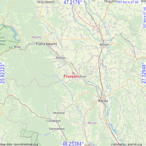
Frunzeni GPS coordinates[2]
46° 44' 16.332" North, 26° 37' 34.86" East
| Map corner | latitude | longitude |
|---|---|---|
| Upper-left | 47.2176°, | 25.92323° |
| Center: | 46.73787°, | 26.62635° |
| Lower-right: | 46.25384°, | 27.32948° |
| Map W x H: | 107.2×107.2 km | = 66.6×66.6mi |
| max Lat: | 48.23793° ⇑27.5% North |
| Frunzeni: | 46.73787° |
| min Lat: | ⇓72.5% South 43.65638° |
| min Long | Frunzeni | max Long |
| 20.31667° | 26.62635° | 29.65403° |
| W 75%⇐ | ⇒25% E |
Elevation
Elevation of Frunzeni is 223 m = 732 ft, and this is 31.9 m = 105 ft below average elevation for this country.
| Max E: |
1278 m = 4193 ft | 47.8% |
| Avg. | 254.9 m = 836 ft | |
| Frunzeni | 223 m = 732 ft | |
Min E: |
-2 m = -7 ft | 52.2% |
See also: Romania elevation on elevation.city.
Geographical zone
Frunzeni is located in North temperate zone (between Tropic of Cancer and the Arctic Circle). Distance of this North polar circle is 2204.4 km =1369.8 mi to North.| Distance of | km | miles | from Frunzeni |
|---|---|---|---|
| North Pole | 4810.3 | 2989 | to North |
| Arctic Circle | 2204.4 | 1369.8 | to North |
| Tropic Cancer | 2590.8 | 1609.8 | to South |
| Equator | 5196.8 | 3229.1 | to South |


Nearby cities:
15 places around Frunzeni: (largest is in red/bold)
• Bețești
3.3 km =2.1 mi,  278°
278°
• Blăgeşti
6.3 km =3.9 mi,  163°
163°
• Buhuşi
6.1 km =3.8 mi,  112°
112°
• Bărcăneşti
4 km =2.5 mi,  234°
234°
• Costişa
2.3 km =1.4 mi,  53°
53°
• Cândeşti
4 km =2.5 mi, 234°
• Mănoaia
3 km =1.9 mi,  6°
6°
• Podoleni
6.9 km =4.3 mi,  353°
353°
• Poloboc
6.4 km =4 mi,  293°
293°
• Rediu
5.3 km =3.3 mi, 292°
• Români
6.7 km =4.2 mi,  40°
40°
• Siliștea
6.7 km =4.2 mi, 48°
• Socea
4.7 km =2.9 mi,  271°
271°
• Valea lui Ion
3.8 km =2.4 mi,  181°
181°
• Vădurele
4.3 km =2.7 mi,  257°
257°
Sources, notices
• [Note1] Compared only with cities in Romania existing in our database
• [Src1] Map data: © OpenStreetMap contributors (CC-BY-SA)
• [Src2] Other city data from geonames.org with taken over terms of usage.
• [Src3] Geographical zone / Annual Mean Temperature by Robert A. Rohde @ Wikipedia
