Blăgeşti geodata
Blăgeşti (Bacău) is a seat of a second-order administrative division; located in Romania in Europe/Bucharest (GMT+3) time zone. With population of 7,165 people, there are 385 cities with bigger population in this country. Compared to other cities in Romania, 71.1% of cities are located further ↓South; 75.5% of cities are located further ←West and 71.3% of cities have lower elevation than Blăgeşti. Note1


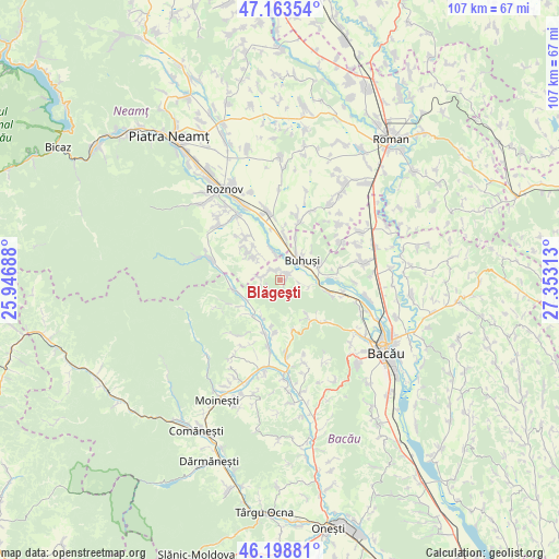
Blăgeşti GPS coordinates[2]
46° 40' 59.988" North, 26° 39' 0" East
| Map corner | latitude | longitude |
|---|---|---|
| Upper-left | 47.16354°, | 25.94688° |
| Center: | 46.68333°, | 26.65° |
| Lower-right: | 46.19881°, | 27.35313° |
| Map W x H: | 107.3×107.3 km | = 66.7×66.7mi |
| max Lat: | 48.23793° ⇑28.9% North |
| Blăgeşti: | 46.68333° |
| min Lat: | ⇓71.1% South 43.65638° |
| min Long | Blăgeşti | max Long |
| 20.31667° | 26.65° | 29.65403° |
| W 75.5%⇐ | ⇒24.5% E |
Elevation
Elevation of Blăgeşti is 329 m = 1079 ft, and this is 74.1 m = 243 ft above average elevation for this country.
| Max E: |
1278 m = 4193 ft | 28.7% |
| Blăgeşti | 329 m 1079 ft | |
| Avg. | 254.9 m = 836 ft | |
Min E: |
-2 m = -7 ft | 71.3% |
See also: Romania elevation on elevation.city.
Geographical zone
Blăgeşti is located in North temperate zone (between Tropic of Cancer and the Arctic Circle). Distance of this North polar circle is 2210.5 km =1373.5 mi to North.| Distance of | km | miles | from Blăgeşti |
|---|---|---|---|
| North Pole | 4816.4 | 2992.8 | to North |
| Arctic Circle | 2210.5 | 1373.5 | to North |
| Tropic Cancer | 2584.8 | 1606.1 | to South |
| Equator | 5190.7 | 3225.4 | to South |


Nearby cities:
15 places around Blăgeşti: (largest is in red/bold)
• Bețești
8.3 km =5.2 mi,  322°
322°
• Buda
5.5 km =3.4 mi,  104°
104°
• Buhuşi
5.3 km =3.3 mi,  45°
45°
• Bărcăneşti
6.3 km =3.9 mi,  306°
306°
• Băsăști
7.5 km =4.7 mi,  209°
209°
• Costişa
7.4 km =4.6 mi,  0°
0°
• Cândeşti
6.3 km =3.9 mi, 306°
• Frumoasa
8.5 km =5.3 mi,  254°
254°
• Frunzeni
6.3 km =3.9 mi,  343°
343°
• Ludași
8.9 km =5.5 mi,  217°
217°
• Mănoaia
9.1 km =5.7 mi,  350°
350°
• Racova
7.8 km =4.8 mi,  76°
76°
• Socea
9 km =5.6 mi, 313°
• Valea lui Ion
2.9 km =1.8 mi, 319°
• Vădurele
7.9 km =4.9 mi, 310°
Sources, notices
• [Note1] Compared only with cities in Romania existing in our database
• [Src1] Map data: © OpenStreetMap contributors (CC-BY-SA)
• [Src2] Other city data from geonames.org with taken over terms of usage.
• [Src3] Geographical zone / Annual Mean Temperature by Robert A. Rohde @ Wikipedia
