Fântânele geodata
Fântânele (Suceava) is a populated place; located in Romania in Europe/Bucharest (GMT+3) time zone. With population of 4,913 people, there are 816 cities with bigger population in this country. Compared to other cities in Romania, 91.2% of cities are located further ↓South; 69.1% of cities are located further ←West and 77.9% of cities have lower elevation than Fântânele. Note1


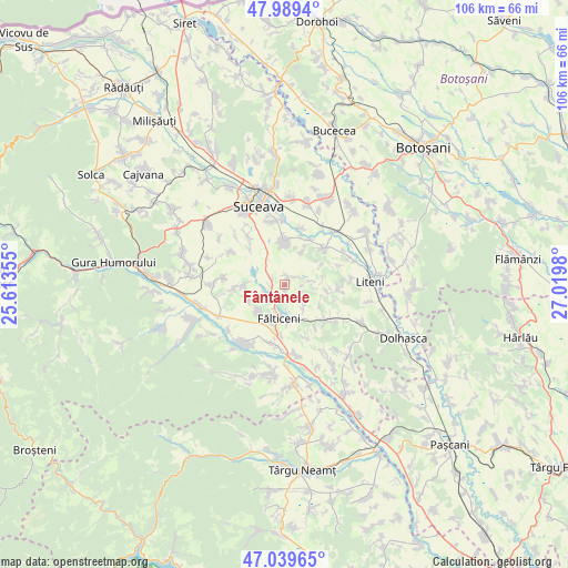
Fântânele GPS coordinates[2]
47° 31' 0.012" North, 26° 19' 0.012" East
| Map corner | latitude | longitude |
|---|---|---|
| Upper-left | 47.9894°, | 25.61355° |
| Center: | 47.51667°, | 26.31667° |
| Lower-right: | 47.03965°, | 27.0198° |
| Map W x H: | 105.6×105.6 km | = 65.6×65.6mi |
| max Lat: | 48.23793° ⇑8.8% North |
| Fântânele: | 47.51667° |
| min Lat: | ⇓91.2% South 43.65638° |
| min Long | Fântânele | max Long |
| 20.31667° | 26.31667° | 29.65403° |
| W 69.1%⇐ | ⇒30.9% E |
Elevation
Elevation of Fântânele is 375 m = 1230 ft, and this is 120.1 m = 394 ft above average elevation for this country.
| Max E: |
1278 m = 4193 ft | 22.1% |
| Fântânele | 375 m 1230 ft | |
| Avg. | 254.9 m = 836 ft | |
Min E: |
-2 m = -7 ft | 77.9% |
See also: Romania elevation on elevation.city.
Geographical zone
Fântânele is located in North temperate zone (between Tropic of Cancer and the Arctic Circle). Distance of this North polar circle is 2117.8 km =1315.9 mi to North.| Distance of | km | miles | from Fântânele |
|---|---|---|---|
| North Pole | 4723.7 | 2935.2 | to North |
| Arctic Circle | 2117.8 | 1315.9 | to North |
| Tropic Cancer | 2677.4 | 1663.7 | to South |
| Equator | 5283.4 | 3283 | to South |


Nearby cities:
15 places around Fântânele: (largest is in red/bold)
• Bosanci
7.4 km =4.6 mi,  0°
0°
• Bunești
2.3 km =1.4 mi,  293°
293°
• Fălticeni
7.5 km =4.7 mi,  189°
189°
• Giurgești
8.1 km =5 mi,  100°
100°
• Hârtop
5.1 km =3.2 mi,  125°
125°
• Lămășeni
7.1 km =4.4 mi,  248°
248°
• Mihăiești
7.5 km =4.7 mi,  269°
269°
• Moara Carp
8.4 km =5.2 mi,  311°
311°
• Petia
0.8 km =0.5 mi,  165°
165°
• Pleșești
4.9 km =3 mi,  82°
82°
• Plăvălari
6.6 km =4.1 mi,  29°
29°
• Rădăşeni
7.5 km =4.7 mi,  222°
222°
• Uncești
1.4 km =0.9 mi,  21°
21°
• Șoldănești
7.2 km =4.5 mi,  175°
175°
• Țarna Mare
5 km =3.1 mi, 170°
Sources, notices
• [Note1] Compared only with cities in Romania existing in our database
• [Src1] Map data: © OpenStreetMap contributors (CC-BY-SA)
• [Src2] Other city data from geonames.org with taken over terms of usage.
• [Src3] Geographical zone / Annual Mean Temperature by Robert A. Rohde @ Wikipedia
