Filea geodata
Filea (Mureş) is a populated place; located in Romania in Europe/Bucharest (GMT+3) time zone. With population of 840 people, there are 4882 cities with bigger population in this country. Compared to other cities in Romania, 77.7% of cities are located further ↓South; 54.2% of cities are located further →East and 85.9% of cities have lower elevation than Filea. Note1


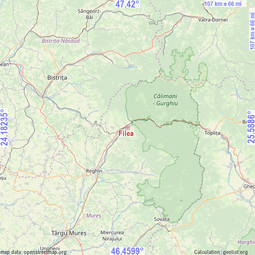
Filea GPS coordinates[2]
46° 56' 31.56" North, 24° 53' 7.692" East
| Map corner | latitude | longitude |
|---|---|---|
| Upper-left | 47.42°, | 24.18235° |
| Center: | 46.9421°, | 24.88547° |
| Lower-right: | 46.4599°, | 25.5886° |
| Map W x H: | 106.8×106.8 km | = 66.4×66.4mi |
| max Lat: | 48.23793° ⇑22.3% North |
| Filea: | 46.9421° |
| min Lat: | ⇓77.7% South 43.65638° |
| min Long | Filea | max Long |
| 20.31667° | 24.88547° | 29.65403° |
| W 45.8%⇐ | ⇒54.2% E |
Elevation
Elevation of Filea is 456 m = 1496 ft, and this is 201.1 m = 660 ft above average elevation for this country.
| Max E: |
1278 m = 4193 ft | 14.1% |
| Filea | 456 m 1496 ft | |
| Avg. | 254.9 m = 836 ft | |
Min E: |
-2 m = -7 ft | 85.9% |
See also: Romania elevation on elevation.city.
Geographical zone
Filea is located in North temperate zone (between Tropic of Cancer and the Arctic Circle). Distance of this North polar circle is 2181.7 km =1355.6 mi to North.| Distance of | km | miles | from Filea |
|---|---|---|---|
| North Pole | 4787.6 | 2974.9 | to North |
| Arctic Circle | 2181.7 | 1355.6 | to North |
| Tropic Cancer | 2613.6 | 1624 | to South |
| Equator | 5219.5 | 3243.2 | to South |


Nearby cities:
15 places around Filea: (largest is in red/bold)
• Aluniş
8.6 km =5.3 mi,  230°
230°
• Bistra Mureșului
2.6 km =1.6 mi,  36°
36°
• Brâncoveneşti
13.5 km =8.4 mi, 225°
• Deda
1.5 km =0.9 mi,  131°
131°
• Dumbrava
6.1 km =3.8 mi,  269°
269°
• Gledin
13.5 km =8.4 mi,  278°
278°
• Luieriu
16.4 km =10.2 mi, 231°
• Lunca Mureșului
10.4 km =6.5 mi,  223°
223°
• Monor
14.3 km =8.9 mi, 280°
• Ruşii Munţi
3.9 km =2.4 mi, 223°
• Râpa de Jos
8.9 km =5.5 mi, 267°
• Răstoliţa
8.8 km =5.5 mi,  67°
67°
• Sebiș
14.7 km =9.1 mi,  299°
299°
• Vălenii de Mureș
8.6 km =5.3 mi, 230°
• Vătava
9.4 km =5.8 mi,  286°
286°
Sources, notices
• [Note1] Compared only with cities in Romania existing in our database
• [Src1] Map data: © OpenStreetMap contributors (CC-BY-SA)
• [Src2] Other city data from geonames.org with taken over terms of usage.
• [Src3] Geographical zone / Annual Mean Temperature by Robert A. Rohde @ Wikipedia
