Eliseni geodata
Eliseni (Harghita) is a populated place; located in Romania in Europe/Bucharest (GMT+3) time zone. With population of 1,104 people, there are 3981 cities with bigger population in this country. Compared to other cities in Romania, 62% of cities are located further ↓South; 53.5% of cities are located further →East and 80.1% of cities have lower elevation than Eliseni. Note1


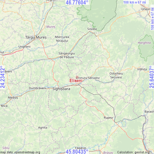
Eliseni GPS coordinates[2]
46° 17' 32.46" North, 24° 56' 14.064" East
| Map corner | latitude | longitude |
|---|---|---|
| Upper-left | 46.77604°, | 24.23412° |
| Center: | 46.29235°, | 24.93724° |
| Lower-right: | 45.80435°, | 25.64037° |
| Map W x H: | 108×108 km | = 67.1×67.1mi |
| max Lat: | 48.23793° ⇑38% North |
| Eliseni: | 46.29235° |
| min Lat: | ⇓62% South 43.65638° |
| min Long | Eliseni | max Long |
| 20.31667° | 24.93724° | 29.65403° |
| W 46.5%⇐ | ⇒53.5% E |
Elevation
Elevation of Eliseni is 394 m = 1293 ft, and this is 139.1 m = 456 ft above average elevation for this country.
| Max E: |
1278 m = 4193 ft | 19.9% |
| Eliseni | 394 m 1293 ft | |
| Avg. | 254.9 m = 836 ft | |
Min E: |
-2 m = -7 ft | 80.1% |
See also: Romania elevation on elevation.city.
Geographical zone
Eliseni is located in North temperate zone (between Tropic of Cancer and the Arctic Circle). Distance of this North polar circle is 2253.9 km =1400.5 mi to North.| Distance of | km | miles | from Eliseni |
|---|---|---|---|
| North Pole | 4859.8 | 3019.7 | to North |
| Arctic Circle | 2253.9 | 1400.5 | to North |
| Tropic Cancer | 2541.3 | 1579.1 | to South |
| Equator | 5147.2 | 3198.3 | to South |


Nearby cities:
15 places around Eliseni: (largest is in red/bold)
• Albeşti
9.4 km =5.8 mi,  225°
225°
• Avrămeşti
7.6 km =4.7 mi,  53°
53°
• Betești
11.2 km =7 mi,  91°
91°
• Bodogaia
5 km =3.1 mi,  113°
113°
• Boiu
5.7 km =3.5 mi,  239°
239°
• Cristuru Secuiesc
7.5 km =4.7 mi,  97°
97°
• Filiaș
6.9 km =4.3 mi, 110°
• Goagiu
10.8 km =6.7 mi,  41°
41°
• Rugănești
10.6 km =6.6 mi,  82°
82°
• Saschiz
12.3 km =7.6 mi,  169°
169°
• Secuieni
4.5 km =2.8 mi,  139°
139°
• Săcel
0.9 km =0.6 mi,  340°
340°
• Vânători
6.6 km =4.1 mi,  182°
182°
• Șoard
3.4 km =2.1 mi,  194°
194°
• Șoimușu Mic
5.2 km =3.2 mi,  21°
21°
Sources, notices
• [Note1] Compared only with cities in Romania existing in our database
• [Src1] Map data: © OpenStreetMap contributors (CC-BY-SA)
• [Src2] Other city data from geonames.org with taken over terms of usage.
• [Src3] Geographical zone / Annual Mean Temperature by Robert A. Rohde @ Wikipedia
