Drăgoești geodata
Drăgoești (Ialomiţa) is a seat of a second-order administrative division; located in Romania in Europe/Bucharest (GMT+3) time zone. With population of 936 people, there are 4499 cities with bigger population in this country. Compared to other cities in Romania, 83.5% of cities are located further ↑North; 73.5% of cities are located further ←West and 88.2% of cities have higher elevation than Drăgoești. Note1


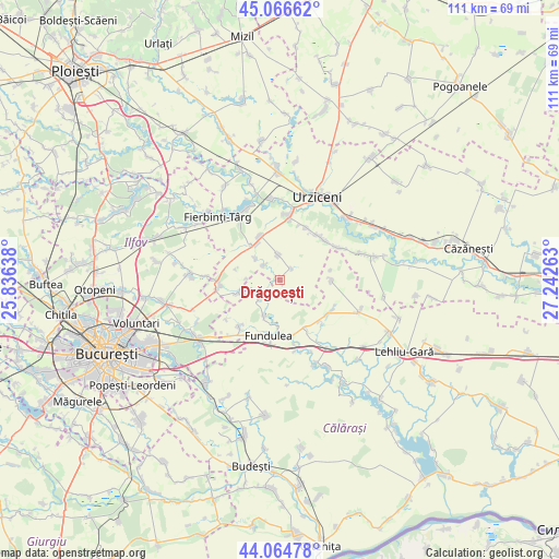
Drăgoești GPS coordinates[2]
44° 34' 4.296" North, 26° 32' 22.2" East
| Map corner | latitude | longitude |
|---|---|---|
| Upper-left | 45.06662°, | 25.83638° |
| Center: | 44.56786°, | 26.5395° |
| Lower-right: | 44.06478°, | 27.24263° |
| Map W x H: | 111.4×111.4 km | = 69.2×69.2mi |
| max Lat: | 48.23793° ⇑83.5% North |
| Drăgoești: | 44.56786° |
| min Lat: | ⇓16.5% South 43.65638° |
| min Long | Drăgoești | max Long |
| 20.31667° | 26.5395° | 29.65403° |
| W 73.5%⇐ | ⇒26.5% E |
Elevation
Elevation of Drăgoești is 66 m = 217 ft, and this is 188.9 m = 620 ft below average elevation for this country.
| Max E: |
1278 m = 4193 ft | 88.2% |
| Avg. | 254.9 m = 836 ft | |
| Drăgoești | 66 m = 217 ft | |
Min E: |
-2 m = -7 ft | 11.8% |
See also: Romania elevation on elevation.city.
Geographical zone
Drăgoești is located in North temperate zone (between Tropic of Cancer and the Arctic Circle). Distance of this Northern Tropic circle is 2349.6 km =1460 mi to South.| Distance of | km | miles | from Drăgoești |
|---|---|---|---|
| North Pole | 5051.6 | 3138.9 | to North |
| Arctic Circle | 2445.7 | 1519.7 | to North |
| Tropic Cancer | 2349.6 | 1460 | to South |
| Equator | 4955.5 | 3079.2 | to South |


Nearby cities:
15 places around Drăgoești: (largest is in red/bold)
• Arțari
10.5 km =6.5 mi,  90°
90°
• Belciugatele
12.6 km =7.8 mi,  221°
221°
• Borănești
11.6 km =7.2 mi,  26°
26°
• Bărcăneşti
11.4 km =7.1 mi,  50°
50°
• Drăgoeşti-Snagov
0.5 km =0.3 mi,  254°
254°
• Florica
11.4 km =7.1 mi,  136°
136°
• Fundulea
11.4 km =7.1 mi,  189°
189°
• Gostilele
7.9 km =4.9 mi,  204°
204°
• Ileana
11.6 km =7.2 mi,  119°
119°
• Lilieci
12.9 km =8 mi,  260°
260°
• Moviliţa
10.2 km =6.3 mi,  334°
334°
• Măriuța
5.7 km =3.5 mi,  229°
229°
• Roșiori
5 km =3.1 mi,  355°
355°
• Sineşti
12.4 km =7.7 mi,  269°
269°
• Tămădău Mare
11.3 km =7 mi,  175°
175°
Sources, notices
• [Note1] Compared only with cities in Romania existing in our database
• [Src1] Map data: © OpenStreetMap contributors (CC-BY-SA)
• [Src2] Other city data from geonames.org with taken over terms of usage.
• [Src3] Geographical zone / Annual Mean Temperature by Robert A. Rohde @ Wikipedia
