Bărcăneşti geodata
Bărcăneşti (Ialomiţa) is a seat of a second-order administrative division; located in Romania in Europe/Bucharest (GMT+3) time zone. With population of 3,936 people, there are 1192 cities with bigger population in this country. Compared to other cities in Romania, 82% of cities are located further ↑North; 75.5% of cities are located further ←West and 85.1% of cities have higher elevation than Bărcăneşti. Note1


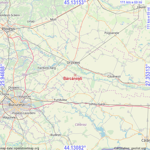
Bărcăneşti GPS coordinates[2]
44° 37' 59.988" North, 26° 39' 0" East
| Map corner | latitude | longitude |
|---|---|---|
| Upper-left | 45.13153°, | 25.94688° |
| Center: | 44.63333°, | 26.65° |
| Lower-right: | 44.13082°, | 27.35313° |
| Map W x H: | 111.3×111.3 km | = 69.2×69.2mi |
| max Lat: | 48.23793° ⇑82% North |
| Bărcăneşti: | 44.63333° |
| min Lat: | ⇓18% South 43.65638° |
| min Long | Bărcăneşti | max Long |
| 20.31667° | 26.65° | 29.65403° |
| W 75.5%⇐ | ⇒24.5% E |
Elevation
Elevation of Bărcăneşti is 78 m = 256 ft, and this is 176.9 m = 580 ft below average elevation for this country.
| Max E: |
1278 m = 4193 ft | 85.1% |
| Avg. | 254.9 m = 836 ft | |
| Bărcăneşti | 78 m = 256 ft | |
Min E: |
-2 m = -7 ft | 14.9% |
See also: Romania elevation on elevation.city.
Geographical zone
Bărcăneşti is located in North temperate zone (between Tropic of Cancer and the Arctic Circle). Distance of this Northern Tropic circle is 2356.8 km =1464.4 mi to South.| Distance of | km | miles | from Bărcăneşti |
|---|---|---|---|
| North Pole | 5044.3 | 3134.4 | to North |
| Arctic Circle | 2438.4 | 1515.2 | to North |
| Tropic Cancer | 2356.8 | 1464.4 | to South |
| Equator | 4962.8 | 3083.7 | to South |


Nearby cities:
15 places around Bărcăneşti: (largest is in red/bold)
• Alexeni
6.8 km =4.2 mi,  35°
35°
• Arțari
7.6 km =4.7 mi,  166°
166°
• Axintele
11.2 km =7 mi,  109°
109°
• Borănești
4.7 km =2.9 mi,  310°
310°
• Broșteni
8.9 km =5.5 mi,  61°
61°
• Bărbulești
11.1 km =6.9 mi,  338°
338°
• Condeești
3.3 km =2.1 mi,  100°
100°
• Coşereni
8.6 km =5.3 mi, 310°
• Drăgoeşti-Snagov
11.8 km =7.3 mi,  231°
231°
• Drăgoești
11.4 km =7.1 mi, 230°
• Ileana
13 km =8.1 mi, 174°
• Ion Roată
9.9 km =6.2 mi,  68°
68°
• Manasia
7.5 km =4.7 mi,  10°
10°
• Roșiori
9.4 km =5.8 mi,  255°
255°
• Urziceni
9.4 km =5.8 mi,  351°
351°
Sources, notices
• [Note1] Compared only with cities in Romania existing in our database
• [Src1] Map data: © OpenStreetMap contributors (CC-BY-SA)
• [Src2] Other city data from geonames.org with taken over terms of usage.
• [Src3] Geographical zone / Annual Mean Temperature by Robert A. Rohde @ Wikipedia
