Drăghiceni geodata
Drăghiceni (Olt) is a seat of a second-order administrative division; located in Romania in Europe/Bucharest (GMT+3) time zone. With population of 1,885 people, there are 2723 cities with bigger population in this country. Compared to other cities in Romania, 94.8% of cities are located further ↑North; 65% of cities are located further →East and 68% of cities have higher elevation than Drăghiceni. Note1


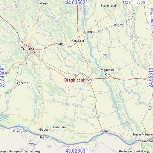
Drăghiceni GPS coordinates[2]
44° 7' 59.988" North, 24° 15' 0" East
| Map corner | latitude | longitude |
|---|---|---|
| Upper-left | 44.63582°, | 23.54688° |
| Center: | 44.13333°, | 24.25° |
| Lower-right: | 43.62653°, | 24.95313° |
| Map W x H: | 112.2×112.2 km | = 69.7×69.7mi |
| max Lat: | 48.23793° ⇑94.8% North |
| Drăghiceni: | 44.13333° |
| min Lat: | ⇓5.2% South 43.65638° |
| min Long | Drăghiceni | max Long |
| 20.31667° | 24.25° | 29.65403° |
| W 35%⇐ | ⇒65% E |
Elevation
Elevation of Drăghiceni is 135 m = 443 ft, and this is 119.9 m = 393 ft below average elevation for this country.
| Max E: |
1278 m = 4193 ft | 68% |
| Avg. | 254.9 m = 836 ft | |
| Drăghiceni | 135 m = 443 ft | |
Min E: |
-2 m = -7 ft | 32% |
See also: Romania elevation on elevation.city.
Geographical zone
Drăghiceni is located in North temperate zone (between Tropic of Cancer and the Arctic Circle). Distance of this Northern Tropic circle is 2301.2 km =1429.9 mi to South.| Distance of | km | miles | from Drăghiceni |
|---|---|---|---|
| North Pole | 5099.9 | 3168.9 | to North |
| Arctic Circle | 2494 | 1549.7 | to North |
| Tropic Cancer | 2301.2 | 1429.9 | to South |
| Equator | 4907.2 | 3049.2 | to South |


Nearby cities:
15 places around Drăghiceni: (largest is in red/bold)
• Caracal
8.2 km =5.1 mi,  103°
103°
• Cezieni
5.7 km =3.5 mi,  13°
13°
• Ciocănești
7.6 km =4.7 mi,  292°
292°
• Comanca
10.6 km =6.6 mi,  125°
125°
• Dioşti
5.6 km =3.5 mi,  250°
250°
• Dobrosloveni
10.8 km =6.7 mi,  59°
59°
• Grozăvești
1.1 km =0.7 mi,  257°
257°
• Liiceni
2.4 km =1.5 mi,  117°
117°
• Osica de Jos
12.6 km =7.8 mi, 10°
• Potopinu
10.6 km =6.6 mi,  50°
50°
• Radomir
6.7 km =4.2 mi, 258°
• Redea
10.1 km =6.3 mi,  156°
156°
• Reșca
12.2 km =7.6 mi,  68°
68°
• Teslui
11.1 km =6.9 mi,  316°
316°
• Zănoaga
12.3 km =7.6 mi,  281°
281°
Sources, notices
• [Note1] Compared only with cities in Romania existing in our database
• [Src1] Map data: © OpenStreetMap contributors (CC-BY-SA)
• [Src2] Other city data from geonames.org with taken over terms of usage.
• [Src3] Geographical zone / Annual Mean Temperature by Robert A. Rohde @ Wikipedia
