Dolhești geodata
Dolhești (Neamţ) is a populated place; located in Romania in Europe/Bucharest (GMT+3) time zone. With population of 1,435 people, there are 3274 cities with bigger population in this country. Compared to other cities in Romania, 84.3% of cities are located further ↓South; 64.5% of cities are located further ←West and 94.9% of cities have lower elevation than Dolhești. Note1


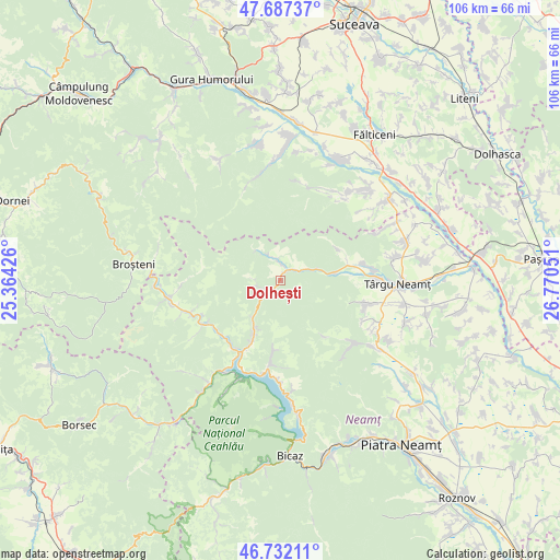
Dolhești GPS coordinates[2]
47° 12' 42.804" North, 26° 4' 2.568" East
| Map corner | latitude | longitude |
|---|---|---|
| Upper-left | 47.68737°, | 25.36426° |
| Center: | 47.21189°, | 26.06738° |
| Lower-right: | 46.73211°, | 26.77051° |
| Map W x H: | 106.2×106.2 km | = 66×66mi |
| max Lat: | 48.23793° ⇑15.7% North |
| Dolhești: | 47.21189° |
| min Lat: | ⇓84.3% South 43.65638° |
| min Long | Dolhești | max Long |
| 20.31667° | 26.06738° | 29.65403° |
| W 64.5%⇐ | ⇒35.5% E |
Elevation
Elevation of Dolhești is 624 m = 2047 ft, and this is 369.1 m = 1211 ft above average elevation for this country.
| Max E: |
1278 m = 4193 ft | 5.1% |
| Dolhești | 624 m 2047 ft | |
| Avg. | 254.9 m = 836 ft | |
Min E: |
-2 m = -7 ft | 94.9% |
See also: Romania elevation on elevation.city.
Geographical zone
Dolhești is located in North temperate zone (between Tropic of Cancer and the Arctic Circle). Distance of this North polar circle is 2151.7 km =1337 mi to North.| Distance of | km | miles | from Dolhești |
|---|---|---|---|
| North Pole | 4757.6 | 2956.2 | to North |
| Arctic Circle | 2151.7 | 1337 | to North |
| Tropic Cancer | 2643.6 | 1642.7 | to South |
| Equator | 5249.5 | 3261.9 | to South |


Nearby cities:
15 places around Dolhești: (largest is in red/bold)
• Agapia
17.1 km =10.6 mi,  107°
107°
• Boboiești
5.2 km =3.2 mi,  334°
334°
• Dreptu
17.9 km =11.1 mi,  238°
238°
• Filioara
17 km =10.6 mi, 109°
• Leghin
10 km =6.2 mi,  81°
81°
• Lunca
17.6 km =10.9 mi, 84°
• Nemțișor
15.8 km =9.8 mi, 78°
• Petru Vodă
11.5 km =7.1 mi,  205°
205°
• Pipirig
4.2 km =2.6 mi,  359°
359°
• Pluton
4.3 km =2.7 mi,  252°
252°
• Poiana Largului
14.6 km =9.1 mi, 207°
• Poiana Teiului
14.6 km =9.1 mi, 211°
• Popești
16.4 km =10.2 mi, 245°
• Stânca
5.3 km =3.3 mi,  66°
66°
• Varatec
17.5 km =10.9 mi,  115°
115°
Sources, notices
• [Note1] Compared only with cities in Romania existing in our database
• [Src1] Map data: © OpenStreetMap contributors (CC-BY-SA)
• [Src2] Other city data from geonames.org with taken over terms of usage.
• [Src3] Geographical zone / Annual Mean Temperature by Robert A. Rohde @ Wikipedia
