Dobrușa geodata
Dobrușa (Vâlcea) is a populated place; located in Romania in Europe/Bucharest (GMT+3) time zone. With population of 1,620 people, there are 3021 cities with bigger population in this country. Compared to other cities in Romania, 82.1% of cities are located further ↑North; 65.8% of cities are located further →East and 53.9% of cities have higher elevation than Dobrușa. Note1


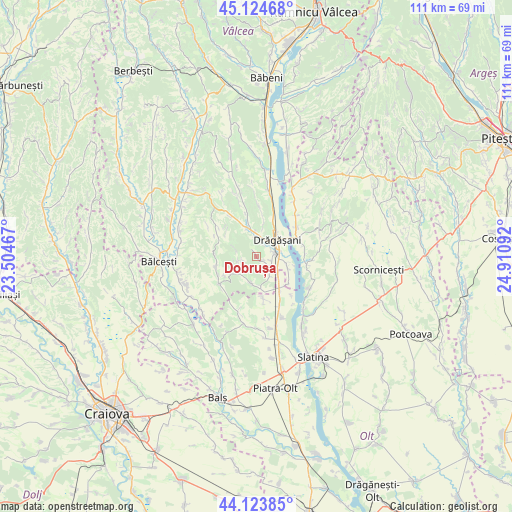
Dobrușa GPS coordinates[2]
44° 37' 35.112" North, 24° 12' 28.044" East
| Map corner | latitude | longitude |
|---|---|---|
| Upper-left | 45.12468°, | 23.50467° |
| Center: | 44.62642°, | 24.20779° |
| Lower-right: | 44.12385°, | 24.91092° |
| Map W x H: | 111.3×111.3 km | = 69.2×69.2mi |
| max Lat: | 48.23793° ⇑82.1% North |
| Dobrușa: | 44.62642° |
| min Lat: | ⇓17.9% South 43.65638° |
| min Long | Dobrușa | max Long |
| 20.31667° | 24.20779° | 29.65403° |
| W 34.2%⇐ | ⇒65.8% E |
Elevation
Elevation of Dobrușa is 192 m = 630 ft, and this is 62.9 m = 206 ft below average elevation for this country.
| Max E: |
1278 m = 4193 ft | 53.9% |
| Avg. | 254.9 m = 836 ft | |
| Dobrușa | 192 m = 630 ft | |
Min E: |
-2 m = -7 ft | 46.1% |
See also: Romania elevation on elevation.city.
Geographical zone
Dobrușa is located in North temperate zone (between Tropic of Cancer and the Arctic Circle). Distance of this Northern Tropic circle is 2356.1 km =1464 mi to South.| Distance of | km | miles | from Dobrușa |
|---|---|---|---|
| North Pole | 5045.1 | 3134.9 | to North |
| Arctic Circle | 2439.2 | 1515.6 | to North |
| Tropic Cancer | 2356.1 | 1464 | to South |
| Equator | 4962 | 3083.2 | to South |


Nearby cities:
15 places around Dobrușa: (largest is in red/bold)
• Boroșești
3.7 km =2.3 mi,  7°
7°
• Creţeni
6.6 km =4.1 mi,  342°
342°
• Drăgăşani
5.3 km =3.3 mi,  60°
60°
• Fumureni
4.1 km =2.5 mi,  255°
255°
• Grădinari
8.1 km =5 mi,  144°
144°
• Lungeşti
6.9 km =4.3 mi,  196°
196°
• Petculești
5.7 km =3.5 mi,  124°
124°
• Streminoasa
6.9 km =4.3 mi, 340°
• Stănești-Lunca
6.5 km =4 mi,  179°
179°
• Sutești
4.7 km =2.9 mi, 6°
• Verdea
7.4 km =4.6 mi, 12°
• Voiceşti
6.7 km =4.2 mi, 116°
• Zlătărei
4 km =2.5 mi,  83°
83°
• Ştefăneşti
3.5 km =2.2 mi,  107°
107°
• Șerbănești
5.2 km =3.2 mi,  146°
146°
Sources, notices
• [Note1] Compared only with cities in Romania existing in our database
• [Src1] Map data: © OpenStreetMap contributors (CC-BY-SA)
• [Src2] Other city data from geonames.org with taken over terms of usage.
• [Src3] Geographical zone / Annual Mean Temperature by Robert A. Rohde @ Wikipedia
