Cornițel geodata
Cornițel (Bihor) is a populated place; located in Romania in Europe/Bucharest (GMT+3) time zone. With population of 631 people, there are 6002 cities with bigger population in this country. Compared to other cities in Romania, 78.8% of cities are located further ↓South; 88.7% of cities are located further →East and 77% of cities have lower elevation than Cornițel. Note1


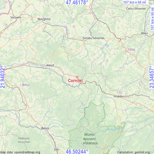
Cornițel GPS coordinates[2]
46° 59' 3.336" North, 22° 38' 36.384" East
| Map corner | latitude | longitude |
|---|---|---|
| Upper-left | 47.46178°, | 21.94032° |
| Center: | 46.98426°, | 22.64344° |
| Lower-right: | 46.50244°, | 23.34657° |
| Map W x H: | 106.7×106.7 km | = 66.3×66.3mi |
| max Lat: | 48.23793° ⇑21.2% North |
| Cornițel: | 46.98426° |
| min Lat: | ⇓78.8% South 43.65638° |
| min Long | Cornițel | max Long |
| 20.31667° | 22.64344° | 29.65403° |
| W 11.3%⇐ | ⇒88.7% E |
Elevation
Elevation of Cornițel is 368 m = 1207 ft, and this is 113.1 m = 371 ft above average elevation for this country.
| Max E: |
1278 m = 4193 ft | 23% |
| Cornițel | 368 m 1207 ft | |
| Avg. | 254.9 m = 836 ft | |
Min E: |
-2 m = -7 ft | 77% |
See also: Romania elevation on elevation.city.
Geographical zone
Cornițel is located in North temperate zone (between Tropic of Cancer and the Arctic Circle). Distance of this North polar circle is 2177 km =1352.7 mi to North.| Distance of | km | miles | from Cornițel |
|---|---|---|---|
| North Pole | 4782.9 | 2972 | to North |
| Arctic Circle | 2177 | 1352.7 | to North |
| Tropic Cancer | 2618.2 | 1626.9 | to South |
| Equator | 5224.2 | 3246.2 | to South |


Nearby cities:
15 places around Cornițel: (largest is in red/bold)
• Beznea
3.3 km =2.1 mi,  213°
213°
• Borod
0.8 km =0.5 mi,  262°
262°
• Borozel
6.6 km =4.1 mi,  291°
291°
• Bratca
6 km =3.7 mi,  199°
199°
• Bucea
5.5 km =3.4 mi,  135°
135°
• Bulz
8.1 km =5 mi,  158°
158°
• Bălnaca
7 km =4.3 mi,  230°
230°
• Lorău
7.6 km =4.7 mi,  186°
186°
• Luncșoara
9.6 km =6 mi,  307°
307°
• Negreni
9.7 km =6 mi,  110°
110°
• Topa de Criș
8.6 km =5.3 mi,  283°
283°
• Vadu Crişului
9.6 km =6 mi,  269°
269°
• Valea Crișului
3.7 km =2.3 mi,  179°
179°
• Valea Mare de Criș
5.3 km =3.3 mi, 280°
• Șerani
6.7 km =4.2 mi,  25°
25°
Sources, notices
• [Note1] Compared only with cities in Romania existing in our database
• [Src1] Map data: © OpenStreetMap contributors (CC-BY-SA)
• [Src2] Other city data from geonames.org with taken over terms of usage.
• [Src3] Geographical zone / Annual Mean Temperature by Robert A. Rohde @ Wikipedia
