Codăeşti geodata
Codăeşti (Vaslui) is a seat of a second-order administrative division; located in Romania in Europe/Bucharest (GMT+3) time zone. With population of 4,785 people, there are 845 cities with bigger population in this country. Compared to other cities in Romania, 75.7% of cities are located further ↓South; 93.7% of cities are located further ←West and 51.6% of cities have higher elevation than Codăeşti. Note1


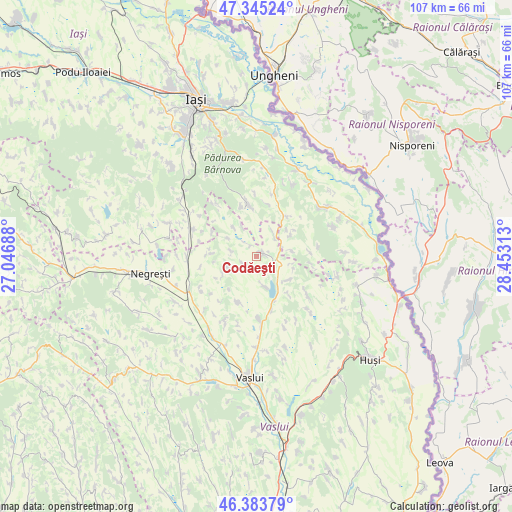
Codăeşti GPS coordinates[2]
46° 52' 0.012" North, 27° 45' 0" East
| Map corner | latitude | longitude |
|---|---|---|
| Upper-left | 47.34524°, | 27.04688° |
| Center: | 46.86667°, | 27.75° |
| Lower-right: | 46.38379°, | 28.45313° |
| Map W x H: | 106.9×106.9 km | = 66.4×66.4mi |
| max Lat: | 48.23793° ⇑24.3% North |
| Codăeşti: | 46.86667° |
| min Lat: | ⇓75.7% South 43.65638° |
| min Long | Codăeşti | max Long |
| 20.31667° | 27.75° | 29.65403° |
| W 93.7%⇐ | ⇒6.3% E |
Elevation
Elevation of Codăeşti is 203 m = 666 ft, and this is 51.9 m = 170 ft below average elevation for this country.
| Max E: |
1278 m = 4193 ft | 51.6% |
| Avg. | 254.9 m = 836 ft | |
| Codăeşti | 203 m = 666 ft | |
Min E: |
-2 m = -7 ft | 48.4% |
See also: Romania elevation on elevation.city.
Geographical zone
Codăeşti is located in North temperate zone (between Tropic of Cancer and the Arctic Circle). Distance of this North polar circle is 2190.1 km =1360.9 mi to North.| Distance of | km | miles | from Codăeşti |
|---|---|---|---|
| North Pole | 4796 | 2980.1 | to North |
| Arctic Circle | 2190.1 | 1360.9 | to North |
| Tropic Cancer | 2605.2 | 1618.8 | to South |
| Equator | 5211.1 | 3238 | to South |


Nearby cities:
15 places around Codăeşti: (largest is in red/bold)
• Chircești
7.9 km =4.9 mi,  106°
106°
• Ciorteşti
7.3 km =4.5 mi,  59°
59°
• Coropceni
10.7 km =6.6 mi,  38°
38°
• Deleni
8.4 km =5.2 mi,  48°
48°
• Dobrovăţ
10 km =6.2 mi,  337°
337°
• Draxeni
9.4 km =5.8 mi,  274°
274°
• Dăneşti
6.6 km =4.1 mi,  253°
253°
• Emil Racoviță
5.4 km =3.4 mi,  275°
275°
• Ferești
10.1 km =6.3 mi,  201°
201°
• Micleşti
8.4 km =5.2 mi,  131°
131°
• Pribești
6 km =3.7 mi, 36°
• Rediu Galian
2.6 km =1.6 mi,  328°
328°
• Tăcuta
7.5 km =4.7 mi,  317°
317°
• Șerbești
7.7 km =4.8 mi,  80°
80°
• Șerbotești
6.7 km =4.2 mi,  161°
161°
Sources, notices
• [Note1] Compared only with cities in Romania existing in our database
• [Src1] Map data: © OpenStreetMap contributors (CC-BY-SA)
• [Src2] Other city data from geonames.org with taken over terms of usage.
• [Src3] Geographical zone / Annual Mean Temperature by Robert A. Rohde @ Wikipedia
