Coca geodata
Coca (Satu Mare) is a populated place; located in Romania in Europe/Bucharest (GMT+3) time zone. With population of 931 people, there are 4511 cities with bigger population in this country. Compared to other cities in Romania, 97.9% of cities are located further ↓South; 80.6% of cities are located further →East and 67.7% of cities have higher elevation than Coca. Note1


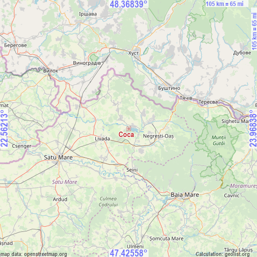
Coca GPS coordinates[2]
47° 53' 56.868" North, 23° 15' 54.9" East
| Map corner | latitude | longitude |
|---|---|---|
| Upper-left | 48.36839°, | 22.56213° |
| Center: | 47.89913°, | 23.26525° |
| Lower-right: | 47.42558°, | 23.96838° |
| Map W x H: | 104.8×104.8 km | = 65.1×65.1mi |
| max Lat: | 48.23793° ⇑2.1% North |
| Coca: | 47.89913° |
| min Lat: | ⇓97.9% South 43.65638° |
| min Long | Coca | max Long |
| 20.31667° | 23.26525° | 29.65403° |
| W 19.4%⇐ | ⇒80.6% E |
Elevation
Elevation of Coca is 136 m = 446 ft, and this is 118.9 m = 390 ft below average elevation for this country.
| Max E: |
1278 m = 4193 ft | 67.7% |
| Avg. | 254.9 m = 836 ft | |
| Coca | 136 m = 446 ft | |
Min E: |
-2 m = -7 ft | 32.3% |
See also: Romania elevation on elevation.city.
Geographical zone
Coca is located in North temperate zone (between Tropic of Cancer and the Arctic Circle). Distance of this North polar circle is 2075.3 km =1289.5 mi to North.| Distance of | km | miles | from Coca |
|---|---|---|---|
| North Pole | 4681.2 | 2908.8 | to North |
| Arctic Circle | 2075.3 | 1289.5 | to North |
| Tropic Cancer | 2720 | 1690.1 | to South |
| Equator | 5325.9 | 3309.4 | to South |


Nearby cities:
15 places around Coca: (largest is in red/bold)
• Adrian
10.3 km =6.4 mi,  272°
272°
• Boinești
6.7 km =4.2 mi,  73°
73°
• Călineşti-Oaş
2.6 km =1.6 mi,  87°
87°
• Gherţa Mică
4.5 km =2.8 mi,  327°
327°
• Gherța Mare
8.8 km =5.5 mi, 331°
• Lechința
3.6 km =2.2 mi,  42°
42°
• Oraşu Nou
7.4 km =4.6 mi,  169°
169°
• Prilog
6.7 km =4.2 mi,  143°
143°
• Racşa
10.1 km =6.3 mi,  150°
150°
• Remetea Oașului
4.7 km =2.9 mi,  123°
123°
• Trip
8.8 km =5.5 mi, 71°
• Tur
9.5 km =5.9 mi,  101°
101°
• Turţ
10 km =6.2 mi,  338°
338°
• Târşolţ
8.5 km =5.3 mi,  48°
48°
• Târşolţel
8.5 km =5.3 mi, 48°
Sources, notices
• [Note1] Compared only with cities in Romania existing in our database
• [Src1] Map data: © OpenStreetMap contributors (CC-BY-SA)
• [Src2] Other city data from geonames.org with taken over terms of usage.
• [Src3] Geographical zone / Annual Mean Temperature by Robert A. Rohde @ Wikipedia
