Coaș geodata
Coaș (Maramureş) is a seat of a second-order administrative division; located in Romania in Europe/Bucharest (GMT+3) time zone. With population of 1,380 people, there are 3375 cities with bigger population in this country. Compared to other cities in Romania, 91.8% of cities are located further ↓South; 75.8% of cities are located further →East and 52.3% of cities have higher elevation than Coaș. Note1


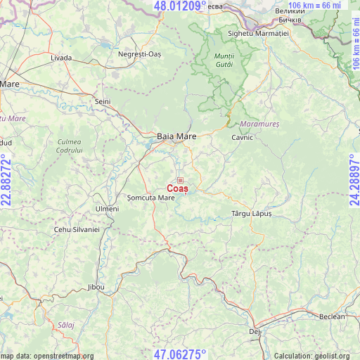
Coaș GPS coordinates[2]
47° 32' 22.452" North, 23° 35' 9.024" East
| Map corner | latitude | longitude |
|---|---|---|
| Upper-left | 48.01209°, | 22.88272° |
| Center: | 47.53957°, | 23.58584° |
| Lower-right: | 47.06275°, | 24.28897° |
| Map W x H: | 105.6×105.6 km | = 65.6×65.6mi |
| max Lat: | 48.23793° ⇑8.2% North |
| Coaș: | 47.53957° |
| min Lat: | ⇓91.8% South 43.65638° |
| min Long | Coaș | max Long |
| 20.31667° | 23.58584° | 29.65403° |
| W 24.2%⇐ | ⇒75.8% E |
Elevation
Elevation of Coaș is 200 m = 656 ft, and this is 54.9 m = 180 ft below average elevation for this country.
| Max E: |
1278 m = 4193 ft | 52.3% |
| Avg. | 254.9 m = 836 ft | |
| Coaș | 200 m = 656 ft | |
Min E: |
-2 m = -7 ft | 47.7% |
See also: Romania elevation on elevation.city.
Geographical zone
Coaș is located in North temperate zone (between Tropic of Cancer and the Arctic Circle). Distance of this North polar circle is 2115.3 km =1314.4 mi to North.| Distance of | km | miles | from Coaș |
|---|---|---|---|
| North Pole | 4721.2 | 2933.6 | to North |
| Arctic Circle | 2115.3 | 1314.4 | to North |
| Tropic Cancer | 2680 | 1665.3 | to South |
| Equator | 5285.9 | 3284.5 | to South |


Nearby cities:
15 places around Coaș: (largest is in red/bold)
• Berchez
6.5 km =4 mi,  248°
248°
• Berchezoaia
5.8 km =3.6 mi,  217°
217°
• Berința
6.8 km =4.2 mi,  88°
88°
• Chechiș
5.2 km =3.2 mi,  15°
15°
• Ciolt
8.1 km =5 mi, 222°
• Coltău
8 km =5 mi,  324°
324°
• Copalnic
5.7 km =3.5 mi,  112°
112°
• Copalnic Mănăştur
8.5 km =5.3 mi,  121°
121°
• Coruia
2.8 km =1.7 mi, 16°
• Culcea
3.7 km =2.3 mi, 322°
• Cărbunari
5.9 km =3.7 mi,  47°
47°
• Dumbrăviţa
8.3 km =5.2 mi,  35°
35°
• Remetea Chioarului
2.8 km =1.7 mi,  255°
255°
• Satu Nou de Jos
8.6 km =5.3 mi,  351°
351°
• Săcălășeni
5 km =3.1 mi,  341°
341°
Sources, notices
• [Note1] Compared only with cities in Romania existing in our database
• [Src1] Map data: © OpenStreetMap contributors (CC-BY-SA)
• [Src2] Other city data from geonames.org with taken over terms of usage.
• [Src3] Geographical zone / Annual Mean Temperature by Robert A. Rohde @ Wikipedia
