Ciupelnița geodata
Ciupelnița (Prahova) is a populated place; located in Romania in Europe/Bucharest (GMT+3) time zone. With population of 747 people, there are 5305 cities with bigger population in this country. Compared to other cities in Romania, 75.1% of cities are located further ↑North; 67.6% of cities are located further ←West and 81.6% of cities have higher elevation than Ciupelnița. Note1


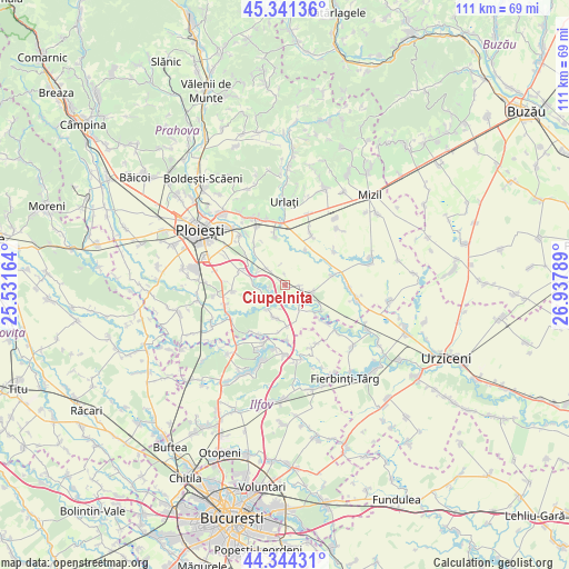
Ciupelnița GPS coordinates[2]
44° 50' 41.964" North, 26° 14' 5.136" East
| Map corner | latitude | longitude |
|---|---|---|
| Upper-left | 45.34136°, | 25.53164° |
| Center: | 44.84499°, | 26.23476° |
| Lower-right: | 44.34431°, | 26.93789° |
| Map W x H: | 110.9×110.9 km | = 68.9×68.9mi |
| max Lat: | 48.23793° ⇑75.1% North |
| Ciupelnița: | 44.84499° |
| min Lat: | ⇓24.9% South 43.65638° |
| min Long | Ciupelnița | max Long |
| 20.31667° | 26.23476° | 29.65403° |
| W 67.6%⇐ | ⇒32.4% E |
Elevation
Elevation of Ciupelnița is 89 m = 292 ft, and this is 165.9 m = 544 ft below average elevation for this country.
| Max E: |
1278 m = 4193 ft | 81.6% |
| Avg. | 254.9 m = 836 ft | |
| Ciupelnița | 89 m = 292 ft | |
Min E: |
-2 m = -7 ft | 18.4% |
See also: Romania elevation on elevation.city.
Geographical zone
Ciupelnița is located in North temperate zone (between Tropic of Cancer and the Arctic Circle). Distance of this Northern Tropic circle is 2380.4 km =1479.1 mi to South.| Distance of | km | miles | from Ciupelnița |
|---|---|---|---|
| North Pole | 5020.8 | 3119.8 | to North |
| Arctic Circle | 2414.9 | 1500.5 | to North |
| Tropic Cancer | 2380.4 | 1479.1 | to South |
| Equator | 4986.3 | 3098.3 | to South |


Nearby cities:
15 places around Ciupelnița: (largest is in red/bold)
• Belciug
3.1 km =1.9 mi,  160°
160°
• Buda
4.5 km =2.8 mi,  239°
239°
• Cioceni
8.1 km =5 mi,  29°
29°
• Cornu de Jos
2.9 km =1.8 mi,  102°
102°
• Cornu de Sus
0.5 km =0.3 mi,  126°
126°
• Drăgăneşti
6 km =3.7 mi,  121°
121°
• Dumbrava
5.9 km =3.7 mi,  316°
316°
• Gherghiţa
5.6 km =3.5 mi,  153°
153°
• Hătcărău
7.9 km =4.9 mi, 119°
• Meri
6 km =3.7 mi, 102°
• Moara Domnească
6.7 km =4.2 mi,  281°
281°
• Olari
6.8 km =4.2 mi,  191°
191°
• Olarii Vechi
6.4 km =4 mi,  202°
202°
• Palanca
4.3 km =2.7 mi,  220°
220°
• Zănoaga
6.1 km =3.8 mi,  293°
293°
Sources, notices
• [Note1] Compared only with cities in Romania existing in our database
• [Src1] Map data: © OpenStreetMap contributors (CC-BY-SA)
• [Src2] Other city data from geonames.org with taken over terms of usage.
• [Src3] Geographical zone / Annual Mean Temperature by Robert A. Rohde @ Wikipedia
