Belciug geodata
Belciug (Prahova) is a populated place; located in Romania in Europe/Bucharest (GMT+3) time zone. With population of 727 people, there are 5418 cities with bigger population in this country. Compared to other cities in Romania, 75.9% of cities are located further ↑North; 67.7% of cities are located further ←West and 84.2% of cities have higher elevation than Belciug. Note1


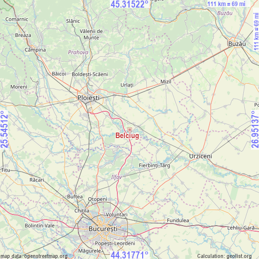
Belciug GPS coordinates[2]
44° 49' 7.032" North, 26° 14' 53.664" East
| Map corner | latitude | longitude |
|---|---|---|
| Upper-left | 45.31522°, | 25.54512° |
| Center: | 44.81862°, | 26.24824° |
| Lower-right: | 44.31771°, | 26.95137° |
| Map W x H: | 110.9×110.9 km | = 68.9×68.9mi |
| max Lat: | 48.23793° ⇑75.9% North |
| Belciug: | 44.81862° |
| min Lat: | ⇓24.1% South 43.65638° |
| min Long | Belciug | max Long |
| 20.31667° | 26.24824° | 29.65403° |
| W 67.7%⇐ | ⇒32.3% E |
Elevation
Elevation of Belciug is 81 m = 266 ft, and this is 173.9 m = 571 ft below average elevation for this country.
| Max E: |
1278 m = 4193 ft | 84.2% |
| Avg. | 254.9 m = 836 ft | |
| Belciug | 81 m = 266 ft | |
Min E: |
-2 m = -7 ft | 15.8% |
See also: Romania elevation on elevation.city.
Geographical zone
Belciug is located in North temperate zone (between Tropic of Cancer and the Arctic Circle). Distance of this Northern Tropic circle is 2377.4 km =1477.2 mi to South.| Distance of | km | miles | from Belciug |
|---|---|---|---|
| North Pole | 5023.7 | 3121.6 | to North |
| Arctic Circle | 2417.8 | 1502.4 | to North |
| Tropic Cancer | 2377.4 | 1477.2 | to South |
| Equator | 4983.4 | 3096.5 | to South |


Nearby cities:
15 places around Belciug: (largest is in red/bold)
• Buda
5 km =3.1 mi,  277°
277°
• Bâra
7.9 km =4.9 mi,  184°
184°
• Ciupelnița
3.1 km =1.9 mi,  340°
340°
• Cornu de Jos
2.9 km =1.8 mi,  36°
36°
• Cornu de Sus
2.7 km =1.7 mi,  345°
345°
• Drăgăneşti
4.1 km =2.5 mi,  93°
93°
• Dumbrava
8.8 km =5.5 mi,  324°
324°
• Gherghiţa
2.5 km =1.6 mi,  144°
144°
• Hătcărău
5.9 km =3.7 mi,  99°
99°
• Meri
5 km =3.1 mi,  70°
70°
• Moara Domnească
8.8 km =5.5 mi,  299°
299°
• Olari
4.5 km =2.8 mi,  213°
213°
• Olarii Vechi
4.6 km =2.9 mi,  229°
229°
• Palanca
3.8 km =2.4 mi,  264°
264°
• Zănoaga
8.6 km =5.3 mi,  308°
308°
Sources, notices
• [Note1] Compared only with cities in Romania existing in our database
• [Src1] Map data: © OpenStreetMap contributors (CC-BY-SA)
• [Src2] Other city data from geonames.org with taken over terms of usage.
• [Src3] Geographical zone / Annual Mean Temperature by Robert A. Rohde @ Wikipedia
