Cernişoara geodata
Cernişoara (Vâlcea) is a seat of a second-order administrative division; located in Romania in Europe/Bucharest (GMT+3) time zone. With population of 3,948 people, there are 1188 cities with bigger population in this country. Compared to other cities in Romania, 68.5% of cities are located further ↑North; 69.7% of cities are located further →East and 79.9% of cities have lower elevation than Cernişoara. Note1


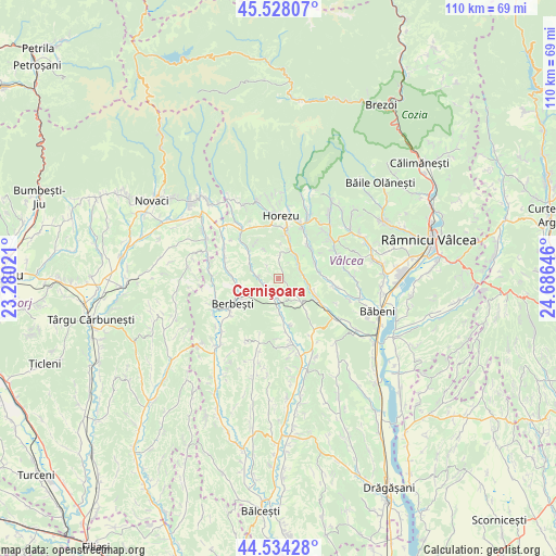
Cernişoara GPS coordinates[2]
45° 1' 59.988" North, 23° 58' 59.988" East
| Map corner | latitude | longitude |
|---|---|---|
| Upper-left | 45.52807°, | 23.28021° |
| Center: | 45.03333°, | 23.98333° |
| Lower-right: | 44.53428°, | 24.68646° |
| Map W x H: | 110.5×110.5 km | = 68.7×68.7mi |
| max Lat: | 48.23793° ⇑68.5% North |
| Cernişoara: | 45.03333° |
| min Lat: | ⇓31.5% South 43.65638° |
| min Long | Cernişoara | max Long |
| 20.31667° | 23.98333° | 29.65403° |
| W 30.3%⇐ | ⇒69.7% E |
Elevation
Elevation of Cernişoara is 392 m = 1286 ft, and this is 137.1 m = 450 ft above average elevation for this country.
| Max E: |
1278 m = 4193 ft | 20.1% |
| Cernişoara | 392 m 1286 ft | |
| Avg. | 254.9 m = 836 ft | |
Min E: |
-2 m = -7 ft | 79.9% |
See also: Romania elevation on elevation.city.
Geographical zone
Cernişoara is located in North temperate zone (between Tropic of Cancer and the Arctic Circle). Distance of this North polar circle is 2393.9 km =1487.5 mi to North.| Distance of | km | miles | from Cernişoara |
|---|---|---|---|
| North Pole | 4999.8 | 3106.7 | to North |
| Arctic Circle | 2393.9 | 1487.5 | to North |
| Tropic Cancer | 2401.3 | 1492.1 | to South |
| Equator | 5007.2 | 3111.3 | to South |


Nearby cities:
15 places around Cernişoara: (largest is in red/bold)
• Armășești
2.9 km =1.8 mi,  125°
125°
• Băltățeni
8.8 km =5.5 mi,  48°
48°
• Cireșu
6.5 km =4 mi,  300°
300°
• Copăceni
3.7 km =2.3 mi,  180°
180°
• Dianu
6.7 km =4.2 mi,  331°
331°
• Foleştii de Jos
8.2 km =5.1 mi,  67°
67°
• Foleștii de Sus
9.1 km =5.7 mi,  41°
41°
• Modoia
8.6 km =5.3 mi,  136°
136°
• Mădulari
1.3 km =0.8 mi,  90°
90°
• Măldăreștii de Jos
8.6 km =5.3 mi,  17°
17°
• Oteşani
5.4 km =3.4 mi, 46°
• Roșioara
8.4 km =5.2 mi,  255°
255°
• Stroeşti
8.6 km =5.3 mi,  310°
310°
• Turcești
9.3 km =5.8 mi,  274°
274°
• Vețelu
6.8 km =4.2 mi, 181°
Sources, notices
• [Note1] Compared only with cities in Romania existing in our database
• [Src1] Map data: © OpenStreetMap contributors (CC-BY-SA)
• [Src2] Other city data from geonames.org with taken over terms of usage.
• [Src3] Geographical zone / Annual Mean Temperature by Robert A. Rohde @ Wikipedia
