Băltățeni geodata
Băltățeni (Vâlcea) is a populated place; located in Romania in Europe/Bucharest (GMT+3) time zone. With population of 509 people, there are 6953 cities with bigger population in this country. Compared to other cities in Romania, 66.1% of cities are located further ↑North; 68.2% of cities are located further →East and 74.9% of cities have lower elevation than Băltățeni. Note1


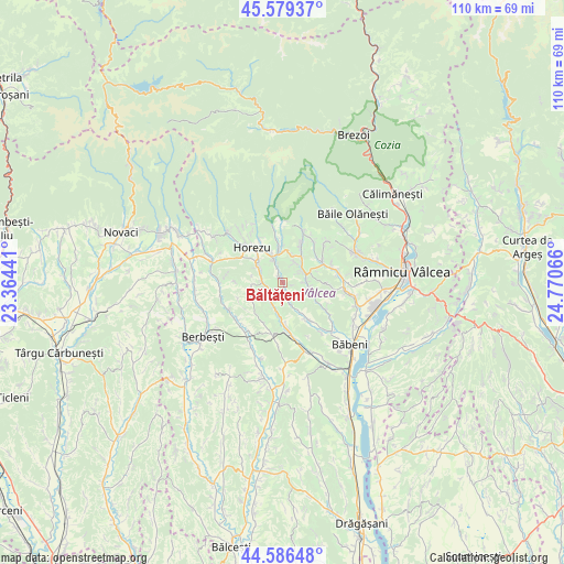
Băltățeni GPS coordinates[2]
45° 5' 6.288" North, 24° 4' 3.108" East
| Map corner | latitude | longitude |
|---|---|---|
| Upper-left | 45.57937°, | 23.36441° |
| Center: | 45.08508°, | 24.06753° |
| Lower-right: | 44.58648°, | 24.77066° |
| Map W x H: | 110.4×110.4 km | = 68.6×68.6mi |
| max Lat: | 48.23793° ⇑66.1% North |
| Băltățeni: | 45.08508° |
| min Lat: | ⇓33.9% South 43.65638° |
| min Long | Băltățeni | max Long |
| 20.31667° | 24.06753° | 29.65403° |
| W 31.8%⇐ | ⇒68.2% E |
Elevation
Elevation of Băltățeni is 352 m = 1155 ft, and this is 97.1 m = 319 ft above average elevation for this country.
| Max E: |
1278 m = 4193 ft | 25.1% |
| Băltățeni | 352 m 1155 ft | |
| Avg. | 254.9 m = 836 ft | |
Min E: |
-2 m = -7 ft | 74.9% |
See also: Romania elevation on elevation.city.
Geographical zone
Băltățeni is located in North temperate zone (between Tropic of Cancer and the Arctic Circle). Distance of this North polar circle is 2388.2 km =1484 mi to North.| Distance of | km | miles | from Băltățeni |
|---|---|---|---|
| North Pole | 4994.1 | 3103.2 | to North |
| Arctic Circle | 2388.2 | 1484 | to North |
| Tropic Cancer | 2407.1 | 1495.7 | to South |
| Equator | 5013 | 3114.9 | to South |


Nearby cities:
15 places around Băltățeni: (largest is in red/bold)
• Bodești
7.3 km =4.5 mi,  30°
30°
• Bogdănești
6.4 km =4 mi,  336°
336°
• Costeşti
7.2 km =4.5 mi,  359°
359°
• Foleştii de Jos
2.8 km =1.7 mi,  160°
160°
• Foleștii de Sus
1.3 km =0.8 mi,  330°
330°
• Genuneni
6.9 km =4.3 mi,  149°
149°
• Mădulari
7.8 km =4.8 mi,  222°
222°
• Măldăreşti
6.4 km =4 mi,  303°
303°
• Măldăreștii de Jos
4.7 km =2.9 mi, 301°
• Negrulești
5.4 km =3.4 mi,  17°
17°
• Oteşani
3.4 km =2.1 mi,  232°
232°
• Pietrari
5.4 km =3.4 mi,  72°
72°
• Pietrarii de Sus
4.1 km =2.5 mi, 29°
• Păuşeşti
5.4 km =3.4 mi,  103°
103°
• Tomşani
3.8 km =2.4 mi, 338°
Sources, notices
• [Note1] Compared only with cities in Romania existing in our database
• [Src1] Map data: © OpenStreetMap contributors (CC-BY-SA)
• [Src2] Other city data from geonames.org with taken over terms of usage.
• [Src3] Geographical zone / Annual Mean Temperature by Robert A. Rohde @ Wikipedia
