Cămărzana geodata
Cămărzana (Satu Mare) is a seat of a second-order administrative division; located in Romania in Europe/Bucharest (GMT+3) time zone. With population of 2,591 people, there are 2074 cities with bigger population in this country. Compared to other cities in Romania, 99.2% of cities are located further ↓South; 79.7% of cities are located further →East and 51.5% of cities have lower elevation than Cămărzana. Note1


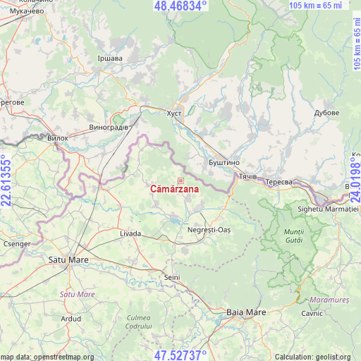
Cămărzana GPS coordinates[2]
48° 0' 0" North, 23° 19' 0.012" East
| Map corner | latitude | longitude |
|---|---|---|
| Upper-left | 48.46834°, | 22.61355° |
| Center: | 48°, | 23.31667° |
| Lower-right: | 47.52737°, | 24.0198° |
| Map W x H: | 104.6×104.6 km | = 65×65mi |
| max Lat: | 48.23793° ⇑0.8% North |
| Cămărzana: | 48° |
| min Lat: | ⇓99.2% South 43.65638° |
| min Long | Cămărzana | max Long |
| 20.31667° | 23.31667° | 29.65403° |
| W 20.3%⇐ | ⇒79.7% E |
Elevation
Elevation of Cămărzana is 219 m = 719 ft, and this is 35.9 m = 118 ft below average elevation for this country.
| Max E: |
1278 m = 4193 ft | 48.5% |
| Avg. | 254.9 m = 836 ft | |
| Cămărzana | 219 m = 719 ft | |
Min E: |
-2 m = -7 ft | 51.5% |
See also: Romania elevation on elevation.city.
Geographical zone
Cămărzana is located in North temperate zone (between Tropic of Cancer and the Arctic Circle). Distance of this North polar circle is 2064.1 km =1282.6 mi to North.| Distance of | km | miles | from Cămărzana |
|---|---|---|---|
| North Pole | 4670 | 2901.8 | to North |
| Arctic Circle | 2064.1 | 1282.6 | to North |
| Tropic Cancer | 2731.2 | 1697.1 | to South |
| Equator | 5337.1 | 3316.3 | to South |


Nearby cities:
15 places around Cămărzana: (largest is in red/bold)
• Bixad
9.7 km =6 mi,  140°
140°
• Boinești
9.7 km =6 mi,  164°
164°
• Bătarci
11.8 km =7.3 mi,  288°
288°
• Coca
11.9 km =7.4 mi,  198°
198°
• Comlăușa
13.3 km =8.3 mi,  295°
295°
• Călineşti-Oaş
11.2 km =7 mi,  186°
186°
• Gherţa Mică
9.7 km =6 mi,  219°
219°
• Gherța Mare
8.8 km =5.5 mi,  246°
246°
• Lechința
8.7 km =5.4 mi, 189°
• Tarna Mare
13.7 km =8.5 mi,  318°
318°
• Trip
9.5 km =5.9 mi,  152°
152°
• Turţ
7.7 km =4.8 mi,  256°
256°
• Târşolţ
6.1 km =3.8 mi, 155°
• Târşolţel
6.1 km =3.8 mi, 155°
• Tămășeni
13.6 km =8.5 mi,  277°
277°
Sources, notices
• [Note1] Compared only with cities in Romania existing in our database
• [Src1] Map data: © OpenStreetMap contributors (CC-BY-SA)
• [Src2] Other city data from geonames.org with taken over terms of usage.
• [Src3] Geographical zone / Annual Mean Temperature by Robert A. Rohde @ Wikipedia
