Calafat geodata
Calafat (Dolj) is a seat of a second-order administrative division; located in Romania in Europe/Bucharest (GMT+3) time zone. With population of 18,643 people, there are 111 cities with bigger population in this country. Compared to other cities in Romania, 97.1% of cities are located further ↑North; 85.4% of cities are located further →East and 92.9% of cities have higher elevation than Calafat. Note1


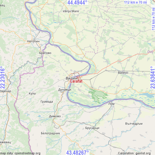
Calafat GPS coordinates[2]
43° 59' 26.484" North, 22° 55' 59.808" East
| Map corner | latitude | longitude |
|---|---|---|
| Upper-left | 44.4944°, | 22.23016° |
| Center: | 43.99069°, | 22.93328° |
| Lower-right: | 43.48267°, | 23.63641° |
| Map W x H: | 112.5×112.5 km | = 69.9×69.9mi |
| max Lat: | 48.23793° ⇑97.1% North |
| Calafat: | 43.99069° |
| min Lat: | ⇓2.9% South 43.65638° |
| min Long | Calafat | max Long |
| 20.31667° | 22.93328° | 29.65403° |
| W 14.6%⇐ | ⇒85.4% E |
Elevation
Elevation of Calafat is 44 m = 144 ft, and this is 210.9 m = 692 ft below average elevation for this country.
| Max E: |
1278 m = 4193 ft | 92.9% |
| Avg. | 254.9 m = 836 ft | |
| Calafat | 44 m = 144 ft | |
Min E: |
-2 m = -7 ft | 7.1% |
See also: Romania elevation on elevation.city.
Geographical zone
Calafat is located in North temperate zone (between Tropic of Cancer and the Arctic Circle). Distance of this Northern Tropic circle is 2285.4 km =1420.1 mi to South.| Distance of | km | miles | from Calafat |
|---|---|---|---|
| North Pole | 5115.8 | 3178.8 | to North |
| Arctic Circle | 2509.9 | 1559.6 | to North |
| Tropic Cancer | 2285.4 | 1420.1 | to South |
| Equator | 4891.3 | 3039.3 | to South |


Nearby cities:
15 places around Calafat: (largest is in red/bold)
• Basarabi
6.3 km =3.9 mi,  74°
74°
• Cetate
15.3 km =9.5 mi,  37°
37°
• Ciupercenii Noi
9.1 km =5.7 mi,  172°
172°
• Ciupercenii Vechi
5.9 km =3.7 mi,  211°
211°
• Desa
15.9 km =9.9 mi,  149°
149°
• Golenți
10.2 km =6.3 mi,  75°
75°
• Hunia
15.1 km =9.4 mi,  61°
61°
• Izimșa
20.9 km =13 mi,  5°
5°
• Maglavit
14.2 km =8.8 mi, 70°
• Moreni
15.8 km =9.8 mi,  46°
46°
• Obârșia de Câmp
20.5 km =12.7 mi, 10°
• Poiana Mare
13.5 km =8.4 mi,  127°
127°
• Salcia
16.7 km =10.4 mi,  358°
358°
• Smârdan
6.8 km =4.2 mi,  157°
157°
• Tunarii Noi
17.5 km =10.9 mi,  112°
112°
Sources, notices
• [Note1] Compared only with cities in Romania existing in our database
• [Src1] Map data: © OpenStreetMap contributors (CC-BY-SA)
• [Src2] Other city data from geonames.org with taken over terms of usage.
• [Src3] Geographical zone / Annual Mean Temperature by Robert A. Rohde @ Wikipedia
