Bujoreni geodata
Bujoreni (Vâlcea) is a seat of a second-order administrative division; located in Romania in Europe/Bucharest (GMT+3) time zone. With population of 3,830 people, there are 1242 cities with bigger population in this country. Compared to other cities in Romania, 64.2% of cities are located further ↑North; 62.8% of cities are located further →East and 81.4% of cities have lower elevation than Bujoreni. Note1


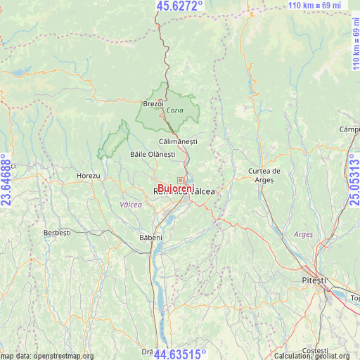
Bujoreni GPS coordinates[2]
45° 7' 59.988" North, 24° 21' 0" East
| Map corner | latitude | longitude |
|---|---|---|
| Upper-left | 45.6272°, | 23.64688° |
| Center: | 45.13333°, | 24.35° |
| Lower-right: | 44.63515°, | 25.05313° |
| Map W x H: | 110.3×110.3 km | = 68.5×68.5mi |
| max Lat: | 48.23793° ⇑64.2% North |
| Bujoreni: | 45.13333° |
| min Lat: | ⇓35.8% South 43.65638° |
| min Long | Bujoreni | max Long |
| 20.31667° | 24.35° | 29.65403° |
| W 37.2%⇐ | ⇒62.8% E |
Elevation
Elevation of Bujoreni is 407 m = 1335 ft, and this is 152.1 m = 499 ft above average elevation for this country.
| Max E: |
1278 m = 4193 ft | 18.6% |
| Bujoreni | 407 m 1335 ft | |
| Avg. | 254.9 m = 836 ft | |
Min E: |
-2 m = -7 ft | 81.4% |
See also: Romania elevation on elevation.city.
Geographical zone
Bujoreni is located in North temperate zone (between Tropic of Cancer and the Arctic Circle). Distance of this North polar circle is 2382.8 km =1480.6 mi to North.| Distance of | km | miles | from Bujoreni |
|---|---|---|---|
| North Pole | 4988.7 | 3099.8 | to North |
| Arctic Circle | 2382.8 | 1480.6 | to North |
| Tropic Cancer | 2412.4 | 1499 | to South |
| Equator | 5018.4 | 3118.3 | to South |


Nearby cities:
15 places around Bujoreni: (largest is in red/bold)
• Bogdănești
4.8 km =3 mi,  353°
353°
• Goranu
4.1 km =2.5 mi,  139°
139°
• Gura Suhașului
6.4 km =4 mi,  218°
218°
• Gura Văii
5.4 km =3.4 mi,  13°
13°
• Lunca
7.5 km =4.7 mi,  237°
237°
• Muereasca
5.7 km =3.5 mi, 346°
• Ocnița
7.6 km =4.7 mi,  229°
229°
• Olteni
3 km =1.9 mi,  63°
63°
• Poenari
3.6 km =2.2 mi,  199°
199°
• Priporu
5.9 km =3.7 mi,  260°
260°
• Racovița
7.1 km =4.4 mi,  148°
148°
• Râmnicu Vâlcea
3.9 km =2.4 mi,  160°
160°
• Sânbotin
6.1 km =3.8 mi,  25°
25°
• Troian
6.1 km =3.8 mi,  180°
180°
• Vlădeşti
4.3 km =2.7 mi, 244°
Sources, notices
• [Note1] Compared only with cities in Romania existing in our database
• [Src1] Map data: © OpenStreetMap contributors (CC-BY-SA)
• [Src2] Other city data from geonames.org with taken over terms of usage.
• [Src3] Geographical zone / Annual Mean Temperature by Robert A. Rohde @ Wikipedia
