Târgu Bujor geodata
Târgu Bujor (Galaţi) is a seat of a second-order administrative division; located in Romania in Europe/Bucharest (GMT+3) time zone. With population of 4,121 people, there are 1123 cities with bigger population in this country. Compared to other cities in Romania, 51.8% of cities are located further ↓South; 95.4% of cities are located further ←West and 67.4% of cities have higher elevation than Târgu Bujor. Note1


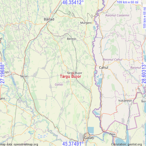
Târgu Bujor GPS coordinates[2]
45° 52' 0.012" North, 27° 54' 0" East
| Map corner | latitude | longitude |
|---|---|---|
| Upper-left | 46.35412°, | 27.19688° |
| Center: | 45.86667°, | 27.9° |
| Lower-right: | 45.37491°, | 28.60313° |
| Map W x H: | 108.9×108.9 km | = 67.7×67.7mi |
| max Lat: | 48.23793° ⇑48.2% North |
| Târgu Bujor: | 45.86667° |
| min Lat: | ⇓51.8% South 43.65638° |
| min Long | Târgu Bujor | max Long |
| 20.31667° | 27.9° | 29.65403° |
| W 95.4%⇐ | ⇒4.6% E |
Elevation
Elevation of Târgu Bujor is 137 m = 449 ft, and this is 117.9 m = 387 ft below average elevation for this country.
| Max E: |
1278 m = 4193 ft | 67.4% |
| Avg. | 254.9 m = 836 ft | |
| Târgu Bujor | 137 m = 449 ft | |
Min E: |
-2 m = -7 ft | 32.6% |
See also: Romania elevation on elevation.city.
Geographical zone
Târgu Bujor is located in North temperate zone (between Tropic of Cancer and the Arctic Circle). Distance of this North polar circle is 2301.3 km =1430 mi to North.| Distance of | km | miles | from Târgu Bujor |
|---|---|---|---|
| North Pole | 4907.2 | 3049.2 | to North |
| Arctic Circle | 2301.3 | 1430 | to North |
| Tropic Cancer | 2494 | 1549.7 | to South |
| Equator | 5099.9 | 3168.9 | to South |


Nearby cities:
15 places around Târgu Bujor: (largest is in red/bold)
• Băleni
7.6 km =4.7 mi,  222°
222°
• Băneasa
7.8 km =4.8 mi,  19°
19°
• Corni
10.5 km =6.5 mi,  259°
259°
• Crăiești
10.9 km =6.8 mi,  321°
321°
• Fârţăneşti
8.5 km =5.3 mi,  130°
130°
• Jorăşti
13.2 km =8.2 mi,  348°
348°
• Moscu
4.7 km =2.9 mi,  31°
31°
• Măcișeni
11.4 km =7.1 mi, 263°
• Măstăcani
13.9 km =8.6 mi, 131°
• Roșcani
10.9 km =6.8 mi,  61°
61°
• Smulţi
13.8 km =8.6 mi,  302°
302°
• Umbrărești
2.5 km =1.6 mi,  144°
144°
• Urlești
8.9 km =5.5 mi,  290°
290°
• Viile
7.6 km =4.7 mi,  151°
151°
• Vârlezi
5.4 km =3.4 mi,  313°
313°
Sources, notices
• [Note1] Compared only with cities in Romania existing in our database
• [Src1] Map data: © OpenStreetMap contributors (CC-BY-SA)
• [Src2] Other city data from geonames.org with taken over terms of usage.
• [Src3] Geographical zone / Annual Mean Temperature by Robert A. Rohde @ Wikipedia
