Buhalnița geodata
Buhalnița (Neamţ) is a populated place; located in Romania in Europe/Bucharest (GMT+3) time zone. With population of 887 people, there are 4672 cities with bigger population in this country. Compared to other cities in Romania, 79.5% of cities are located further ↓South; 64.9% of cities are located further ←West and 90.1% of cities have lower elevation than Buhalnița. Note1


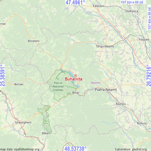
Buhalnița GPS coordinates[2]
47° 1' 8.004" North, 26° 5' 20.508" East
| Map corner | latitude | longitude |
|---|---|---|
| Upper-left | 47.4961°, | 25.38591° |
| Center: | 47.01889°, | 26.08903° |
| Lower-right: | 46.53738°, | 26.79216° |
| Map W x H: | 106.6×106.6 km | = 66.2×66.2mi |
| max Lat: | 48.23793° ⇑20.5% North |
| Buhalnița: | 47.01889° |
| min Lat: | ⇓79.5% South 43.65638° |
| min Long | Buhalnița | max Long |
| 20.31667° | 26.08903° | 29.65403° |
| W 64.9%⇐ | ⇒35.1% E |
Elevation
Elevation of Buhalnița is 514 m = 1686 ft, and this is 259.1 m = 850 ft above average elevation for this country.
| Max E: |
1278 m = 4193 ft | 9.9% |
| Buhalnița | 514 m 1686 ft | |
| Avg. | 254.9 m = 836 ft | |
Min E: |
-2 m = -7 ft | 90.1% |
See also: Romania elevation on elevation.city.
Geographical zone
Buhalnița is located in North temperate zone (between Tropic of Cancer and the Arctic Circle). Distance of this North polar circle is 2173.2 km =1350.4 mi to North.| Distance of | km | miles | from Buhalnița |
|---|---|---|---|
| North Pole | 4779.1 | 2969.6 | to North |
| Arctic Circle | 2173.2 | 1350.4 | to North |
| Tropic Cancer | 2622.1 | 1629.3 | to South |
| Equator | 5228 | 3248.5 | to South |


Nearby cities:
15 places around Buhalnița: (largest is in red/bold)
• Bicaz
11.5 km =7.1 mi,  188°
188°
• Bistricioara
12.8 km =8 mi,  287°
287°
• Capșa
12.8 km =8 mi,  172°
172°
• Ceahlău
9.9 km =6.2 mi, 290°
• Cracăul Negru
14.2 km =8.8 mi,  54°
54°
• Dodeni
10.3 km =6.4 mi,  178°
178°
• Hangu
5.5 km =3.4 mi,  309°
309°
• Petru Vodă
13 km =8.1 mi,  329°
329°
• Poiana Largului
11.9 km =7.4 mi,  315°
315°
• Poiana Teiului
12.9 km =8 mi, 314°
• Pângăraţi
10.6 km =6.6 mi,  154°
154°
• Pângărăcior
13.6 km =8.5 mi,  134°
134°
• Stejaru
13.1 km =8.1 mi, 148°
• Straja
14.3 km =8.9 mi, 154°
• Taşca
14.3 km =8.9 mi,  202°
202°
Sources, notices
• [Note1] Compared only with cities in Romania existing in our database
• [Src1] Map data: © OpenStreetMap contributors (CC-BY-SA)
• [Src2] Other city data from geonames.org with taken over terms of usage.
• [Src3] Geographical zone / Annual Mean Temperature by Robert A. Rohde @ Wikipedia
