Buciumeni geodata
Buciumeni (Galaţi) is a seat of a second-order administrative division; located in Romania in Europe/Bucharest (GMT+3) time zone. With population of 2,658 people, there are 2012 cities with bigger population in this country. Compared to other cities in Romania, 55% of cities are located further ↓South; 88.3% of cities are located further ←West and 51.6% of cities have higher elevation than Buciumeni. Note1


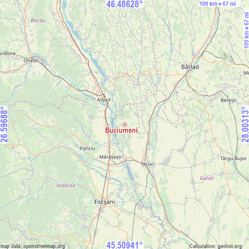
Buciumeni GPS coordinates[2]
46° 0' 0" North, 27° 18' 0" East
| Map corner | latitude | longitude |
|---|---|---|
| Upper-left | 46.48628°, | 26.59688° |
| Center: | 46°, | 27.3° |
| Lower-right: | 45.50941°, | 28.00313° |
| Map W x H: | 108.6×108.6 km | = 67.5×67.5mi |
| max Lat: | 48.23793° ⇑45% North |
| Buciumeni: | 46° |
| min Lat: | ⇓55% South 43.65638° |
| min Long | Buciumeni | max Long |
| 20.31667° | 27.3° | 29.65403° |
| W 88.3%⇐ | ⇒11.7% E |
Elevation
Elevation of Buciumeni is 203 m = 666 ft, and this is 51.9 m = 170 ft below average elevation for this country.
| Max E: |
1278 m = 4193 ft | 51.6% |
| Avg. | 254.9 m = 836 ft | |
| Buciumeni | 203 m = 666 ft | |
Min E: |
-2 m = -7 ft | 48.4% |
See also: Romania elevation on elevation.city.
Geographical zone
Buciumeni is located in North temperate zone (between Tropic of Cancer and the Arctic Circle). Distance of this North polar circle is 2286.5 km =1420.8 mi to North.| Distance of | km | miles | from Buciumeni |
|---|---|---|---|
| North Pole | 4892.3 | 3039.9 | to North |
| Arctic Circle | 2286.5 | 1420.8 | to North |
| Tropic Cancer | 2508.8 | 1558.9 | to South |
| Equator | 5114.7 | 3178.1 | to South |


Nearby cities:
15 places around Buciumeni: (largest is in red/bold)
• Brăhăşeştii de Sus
6.8 km =4.2 mi,  34°
34°
• Brăhășești
6.3 km =3.9 mi,  54°
54°
• Ciorani
6.6 km =4.1 mi,  258°
258°
• Călimănești
7.6 km =4.7 mi,  236°
236°
• Fântâni
5.1 km =3.2 mi,  188°
188°
• Hănțești
4.1 km =2.5 mi,  169°
169°
• Nicoreşti
7.6 km =4.7 mi, 174°
• Nărtești
8.5 km =5.3 mi,  80°
80°
• Ploscuțeni
9 km =5.6 mi,  345°
345°
• Poiana
3.5 km =2.2 mi, 255°
• Pufeşti
7.7 km =4.8 mi,  270°
270°
• Pădureni
8.8 km =5.5 mi,  217°
217°
• Tecucelu Sec
3.1 km =1.9 mi,  132°
132°
• Toflea
7.6 km =4.7 mi,  20°
20°
• Ţepu
6.3 km =3.9 mi, 125°
Sources, notices
• [Note1] Compared only with cities in Romania existing in our database
• [Src1] Map data: © OpenStreetMap contributors (CC-BY-SA)
• [Src2] Other city data from geonames.org with taken over terms of usage.
• [Src3] Geographical zone / Annual Mean Temperature by Robert A. Rohde @ Wikipedia
