Nărtești geodata
Nărtești (Galaţi) is a populated place; located in Romania in Europe/Bucharest (GMT+3) time zone. With population of 882 people, there are 4695 cities with bigger population in this country. Compared to other cities in Romania, 55.3% of cities are located further ↓South; 89.7% of cities are located further ←West and 69% of cities have higher elevation than Nărtești. Note1


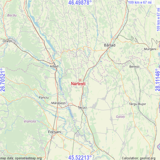
Nărtești GPS coordinates[2]
46° 0' 45.396" North, 27° 24' 29.988" East
| Map corner | latitude | longitude |
|---|---|---|
| Upper-left | 46.49878°, | 26.70521° |
| Center: | 46.01261°, | 27.40833° |
| Lower-right: | 45.52213°, | 28.11146° |
| Map W x H: | 108.6×108.6 km | = 67.5×67.5mi |
| max Lat: | 48.23793° ⇑44.7% North |
| Nărtești: | 46.01261° |
| min Lat: | ⇓55.3% South 43.65638° |
| min Long | Nărtești | max Long |
| 20.31667° | 27.40833° | 29.65403° |
| W 89.7%⇐ | ⇒10.3% E |
Elevation
Elevation of Nărtești is 131 m = 430 ft, and this is 123.9 m = 406 ft below average elevation for this country.
| Max E: |
1278 m = 4193 ft | 69% |
| Avg. | 254.9 m = 836 ft | |
| Nărtești | 131 m = 430 ft | |
Min E: |
-2 m = -7 ft | 31% |
See also: Romania elevation on elevation.city.
Geographical zone
Nărtești is located in North temperate zone (between Tropic of Cancer and the Arctic Circle). Distance of this North polar circle is 2285.1 km =1419.9 mi to North.| Distance of | km | miles | from Nărtești |
|---|---|---|---|
| North Pole | 4890.9 | 3039.1 | to North |
| Arctic Circle | 2285.1 | 1419.9 | to North |
| Tropic Cancer | 2510.2 | 1559.8 | to South |
| Equator | 5116.1 | 3179 | to South |


Nearby cities:
15 places around Nărtești: (largest is in red/bold)
• Brăhăşeştii de Sus
6.1 km =3.8 mi,  312°
312°
• Brăhășești
4 km =2.5 mi, 305°
• Buciumeni
8.5 km =5.3 mi,  260°
260°
• Gara Berheci
4.8 km =3 mi,  152°
152°
• Ghidigeni
8.2 km =5.1 mi,  59°
59°
• Gohor
6 km =3.7 mi,  353°
353°
• Hănțești
9.4 km =5.8 mi,  234°
234°
• Munteni
9 km =5.6 mi,  167°
167°
• Negrilești
8.3 km =5.2 mi,  137°
137°
• Priponeşti
8.1 km =5 mi,  13°
13°
• Slobozia Corni
6 km =3.7 mi,  112°
112°
• Tecucelu Sec
7 km =4.3 mi,  240°
240°
• Toflea
8.1 km =5 mi, 314°
• Tălpigi
5 km =3.1 mi,  95°
95°
• Ţepu
6 km =3.7 mi,  212°
212°
Sources, notices
• [Note1] Compared only with cities in Romania existing in our database
• [Src1] Map data: © OpenStreetMap contributors (CC-BY-SA)
• [Src2] Other city data from geonames.org with taken over terms of usage.
• [Src3] Geographical zone / Annual Mean Temperature by Robert A. Rohde @ Wikipedia
