Brăneşti geodata
Brăneşti (Gorj) is a seat of a second-order administrative division; located in Romania in Europe/Bucharest (GMT+3) time zone. With population of 2,516 people, there are 2148 cities with bigger population in this country. Compared to other cities in Romania, 81.6% of cities are located further ↑North; 77.6% of cities are located further →East and 58.7% of cities have higher elevation than Brăneşti. Note1


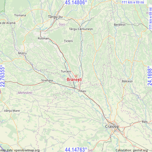
Brăneşti GPS coordinates[2]
44° 39' 0" North, 23° 28' 0.012" East
| Map corner | latitude | longitude |
|---|---|---|
| Upper-left | 45.14806°, | 22.76355° |
| Center: | 44.65°, | 23.46667° |
| Lower-right: | 44.14763°, | 24.1698° |
| Map W x H: | 111.2×111.2 km | = 69.1×69.1mi |
| max Lat: | 48.23793° ⇑81.6% North |
| Brăneşti: | 44.65° |
| min Lat: | ⇓18.4% South 43.65638° |
| min Long | Brăneşti | max Long |
| 20.31667° | 23.46667° | 29.65403° |
| W 22.4%⇐ | ⇒77.6% E |
Elevation
Elevation of Brăneşti is 171 m = 561 ft, and this is 83.9 m = 275 ft below average elevation for this country.
| Max E: |
1278 m = 4193 ft | 58.7% |
| Avg. | 254.9 m = 836 ft | |
| Brăneşti | 171 m = 561 ft | |
Min E: |
-2 m = -7 ft | 41.3% |
See also: Romania elevation on elevation.city.
Geographical zone
Brăneşti is located in North temperate zone (between Tropic of Cancer and the Arctic Circle). Distance of this Northern Tropic circle is 2358.7 km =1465.6 mi to South.| Distance of | km | miles | from Brăneşti |
|---|---|---|---|
| North Pole | 5042.4 | 3133.2 | to North |
| Arctic Circle | 2436.6 | 1514 | to North |
| Tropic Cancer | 2358.7 | 1465.6 | to South |
| Equator | 4964.6 | 3084.9 | to South |


Nearby cities:
15 places around Brăneşti: (largest is in red/bold)
• Arginești
9.4 km =5.8 mi,  205°
205°
• Bulbuceni
10.6 km =6.6 mi,  55°
55°
• Capu Dealului
2.5 km =1.6 mi,  158°
158°
• Cocorova
7.2 km =4.5 mi,  83°
83°
• Costești
9.3 km =5.8 mi,  349°
349°
• Florești
6 km =3.7 mi,  125°
125°
• Groșerea
7.9 km =4.9 mi,  8°
8°
• Iliești
5.2 km =3.2 mi,  261°
261°
• Ioneşti
4.5 km =2.8 mi,  215°
215°
• Izvoarele
9.2 km =5.7 mi,  324°
324°
• Poiana
5.1 km =3.2 mi,  87°
87°
• Turburea
8.4 km =5.2 mi,  28°
28°
• Turceni
8.7 km =5.4 mi,  295°
295°
• Ţânţăreni
5.7 km =3.5 mi,  166°
166°
• Șipotu
7.3 km =4.5 mi,  38°
38°
Sources, notices
• [Note1] Compared only with cities in Romania existing in our database
• [Src1] Map data: © OpenStreetMap contributors (CC-BY-SA)
• [Src2] Other city data from geonames.org with taken over terms of usage.
• [Src3] Geographical zone / Annual Mean Temperature by Robert A. Rohde @ Wikipedia
