Arginești geodata
Arginești (Mehedinţi) is a populated place; located in Romania in Europe/Bucharest (GMT+3) time zone. With population of 556 people, there are 6529 cities with bigger population in this country. Compared to other cities in Romania, 83.5% of cities are located further ↑North; 78.3% of cities are located further →East and 75.1% of cities have higher elevation than Arginești. Note1


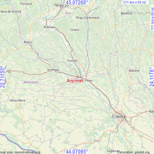
Arginești GPS coordinates[2]
44° 34' 26.292" North, 23° 24' 52.812" East
| Map corner | latitude | longitude |
|---|---|---|
| Upper-left | 45.07268°, | 22.71155° |
| Center: | 44.57397°, | 23.41467° |
| Lower-right: | 44.07095°, | 24.1178° |
| Map W x H: | 111.4×111.4 km | = 69.2×69.2mi |
| max Lat: | 48.23793° ⇑83.5% North |
| Arginești: | 44.57397° |
| min Lat: | ⇓16.5% South 43.65638° |
| min Long | Arginești | max Long |
| 20.31667° | 23.41467° | 29.65403° |
| W 21.7%⇐ | ⇒78.3% E |
Elevation
Elevation of Arginești is 110 m = 361 ft, and this is 144.9 m = 475 ft below average elevation for this country.
| Max E: |
1278 m = 4193 ft | 75.1% |
| Avg. | 254.9 m = 836 ft | |
| Arginești | 110 m = 361 ft | |
Min E: |
-2 m = -7 ft | 24.9% |
See also: Romania elevation on elevation.city.
Geographical zone
Arginești is located in North temperate zone (between Tropic of Cancer and the Arctic Circle). Distance of this Northern Tropic circle is 2350.2 km =1460.3 mi to South.| Distance of | km | miles | from Arginești |
|---|---|---|---|
| North Pole | 5050.9 | 3138.5 | to North |
| Arctic Circle | 2445 | 1519.3 | to North |
| Tropic Cancer | 2350.2 | 1460.3 | to South |
| Equator | 4956.2 | 3079.6 | to South |


Nearby cities:
15 places around Arginești: (largest is in red/bold)
• Argetoaia
7.4 km =4.6 mi,  210°
210°
• Brăneşti
9.4 km =5.8 mi,  25°
25°
• Buicești
4.1 km =2.5 mi,  256°
256°
• Butoieşti
3.9 km =2.4 mi,  285°
285°
• Bâlta
6.1 km =3.8 mi,  134°
134°
• Capu Dealului
8 km =5 mi,  39°
39°
• Filiaşi
8.5 km =5.3 mi,  108°
108°
• Florești
10.3 km =6.4 mi,  60°
60°
• Iliești
7.7 km =4.8 mi,  352°
352°
• Ioneşti
5 km =3.1 mi,  17°
17°
• Pluta
6.7 km =4.2 mi,  270°
270°
• Salcia
10.5 km =6.5 mi,  166°
166°
• Stângăceaua
9 km =5.6 mi,  295°
295°
• Valea Fântânilor
9.7 km =6 mi,  145°
145°
• Ţânţăreni
6.2 km =3.9 mi, 61°
Sources, notices
• [Note1] Compared only with cities in Romania existing in our database
• [Src1] Map data: © OpenStreetMap contributors (CC-BY-SA)
• [Src2] Other city data from geonames.org with taken over terms of usage.
• [Src3] Geographical zone / Annual Mean Temperature by Robert A. Rohde @ Wikipedia
