Brădicești geodata
Brădicești (Iaşi) is a populated place; located in Romania in Europe/Bucharest (GMT+3) time zone. With population of 1,161 people, there are 3827 cities with bigger population in this country. Compared to other cities in Romania, 75.2% of cities are located further ↓South; 95.5% of cities are located further ←West and 54% of cities have lower elevation than Brădicești. Note1


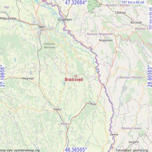
Brădicești GPS coordinates[2]
46° 50' 53.16" North, 27° 54' 9.72" East
| Map corner | latitude | longitude |
|---|---|---|
| Upper-left | 47.32684°, | 27.19958° |
| Center: | 46.8481°, | 27.9027° |
| Lower-right: | 46.36505°, | 28.60583° |
| Map W x H: | 106.9×106.9 km | = 66.4×66.4mi |
| max Lat: | 48.23793° ⇑24.8% North |
| Brădicești: | 46.8481° |
| min Lat: | ⇓75.2% South 43.65638° |
| min Long | Brădicești | max Long |
| 20.31667° | 27.9027° | 29.65403° |
| W 95.5%⇐ | ⇒4.5% E |
Elevation
Elevation of Brădicești is 233 m = 764 ft, and this is 21.9 m = 72 ft below average elevation for this country.
| Max E: |
1278 m = 4193 ft | 46% |
| Avg. | 254.9 m = 836 ft | |
| Brădicești | 233 m = 764 ft | |
Min E: |
-2 m = -7 ft | 54% |
See also: Romania elevation on elevation.city.
Geographical zone
Brădicești is located in North temperate zone (between Tropic of Cancer and the Arctic Circle). Distance of this North polar circle is 2192.2 km =1362.2 mi to North.| Distance of | km | miles | from Brădicești |
|---|---|---|---|
| North Pole | 4798 | 2981.3 | to North |
| Arctic Circle | 2192.2 | 1362.2 | to North |
| Tropic Cancer | 2603.1 | 1617.5 | to South |
| Equator | 5209 | 3236.7 | to South |


Nearby cities:
15 places around Brădicești: (largest is in red/bold)
• Arsura
9.9 km =6.2 mi,  113°
113°
• Boţeşti
5.5 km =3.4 mi,  195°
195°
• Buneşti
5.1 km =3.2 mi, 108°
• Chircești
4.1 km =2.5 mi,  267°
267°
• Ciorteşti
7.8 km =4.8 mi,  317°
317°
• Cozmeşti
7.3 km =4.5 mi,  57°
57°
• Deleni
9.3 km =5.8 mi,  325°
325°
• Dolheşti
2.1 km =1.3 mi,  354°
354°
• Gugești
9.4 km =5.8 mi,  181°
181°
• Micleşti
6.3 km =3.9 mi,  236°
236°
• Moşna
8.4 km =5.2 mi,  25°
25°
• Pietriș
4.3 km =2.7 mi,  18°
18°
• Podolenii de Sus
8.6 km =5.3 mi,  83°
83°
• Șerbești
5.2 km =3.2 mi,  308°
308°
• Șerbotești
10.4 km =6.5 mi,  245°
245°
Sources, notices
• [Note1] Compared only with cities in Romania existing in our database
• [Src1] Map data: © OpenStreetMap contributors (CC-BY-SA)
• [Src2] Other city data from geonames.org with taken over terms of usage.
• [Src3] Geographical zone / Annual Mean Temperature by Robert A. Rohde @ Wikipedia
