Botoroaga geodata
Botoroaga (Teleorman) is a seat of a second-order administrative division; located in Romania in Europe/Bucharest (GMT+3) time zone. With population of 6,488 people, there are 470 cities with bigger population in this country. Compared to other cities in Romania, 94.5% of cities are located further ↑North; 55.2% of cities are located further ←West and 82.5% of cities have higher elevation than Botoroaga. Note1


Botoroaga GPS coordinates[2]
44° 8' 53.988" North, 25° 32' 40.992" East
| Map corner | latitude | longitude |
|---|---|---|
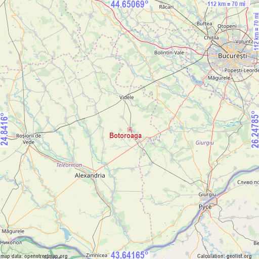
| Upper-left | 44.65069°, | 24.8416° |
| Center: | 44.14833°, | 25.54472° |
| Lower-right: | 43.64165°, | 26.24785° |
| Map W x H: | 112.2×112.2 km | = 69.7×69.7mi |
| max Lat: | 48.23793° ⇑94.5% North |
| Botoroaga: | 44.14833° |
| min Lat: | ⇓5.5% South 43.65638° |
| min Long | Botoroaga | max Long |
| 20.31667° | 25.54472° | 29.65403° |
| W 55.2%⇐ | ⇒44.8% E |
Elevation
Elevation of Botoroaga is 86 m = 282 ft, and this is 168.9 m = 554 ft below average elevation for this country.
| Max E: |
1278 m = 4193 ft | 82.5% |
| Avg. | 254.9 m = 836 ft | |
| Botoroaga | 86 m = 282 ft | |
Min E: |
-2 m = -7 ft | 17.5% |
See also: Romania elevation on elevation.city.
Geographical zone
Botoroaga is located in North temperate zone (between Tropic of Cancer and the Arctic Circle). Distance of this Northern Tropic circle is 2302.9 km =1431 mi to South.| Distance of | km | miles | from Botoroaga |
|---|---|---|---|
| North Pole | 5098.2 | 3167.9 | to North |
| Arctic Circle | 2492.3 | 1548.6 | to North |
| Tropic Cancer | 2302.9 | 1431 | to South |
| Equator | 4908.8 | 3050.2 | to South |


Nearby cities:
15 places around Botoroaga: (largest is in red/bold)
• Bujoreni
7.9 km =4.9 mi,  116°
116°
• Ciuani
12.6 km =7.8 mi,  41°
41°
• Comoara
4.9 km =3 mi,  217°
217°
• Crevenicu
10.9 km =6.8 mi,  18°
18°
• Drăgăneşti-Vlaşca
6.7 km =4.2 mi,  140°
140°
• Letca Veche
12.7 km =7.9 mi,  63°
63°
• Merenii de Jos
12.2 km =7.6 mi, 40°
• Merenii de Sus
10.8 km =6.7 mi,  34°
34°
• Merișani
12.1 km =7.5 mi,  253°
253°
• Moșteni
6.2 km =3.9 mi,  332°
332°
• Prunaru
11.1 km =6.9 mi,  103°
103°
• Rădulești
10.6 km =6.6 mi,  5°
5°
• Răsuceni
11.4 km =7.1 mi, 123°
• Târnava
1.6 km =1 mi,  106°
106°
• Valea Cireșului
2.6 km =1.6 mi, 37°
Sources, notices
• [Note1] Compared only with cities in Romania existing in our database
• [Src1] Map data: © OpenStreetMap contributors (CC-BY-SA)
• [Src2] Other city data from geonames.org with taken over terms of usage.
• [Src3] Geographical zone / Annual Mean Temperature by Robert A. Rohde @ Wikipedia
