Răsuceni geodata
Răsuceni (Giurgiu) is a seat of a second-order administrative division; located in Romania in Europe/Bucharest (GMT+3) time zone. With population of 3,090 people, there are 1699 cities with bigger population in this country. Compared to other cities in Romania, 95.6% of cities are located further ↑North; 57% of cities are located further ←West and 87% of cities have higher elevation than Răsuceni. Note1


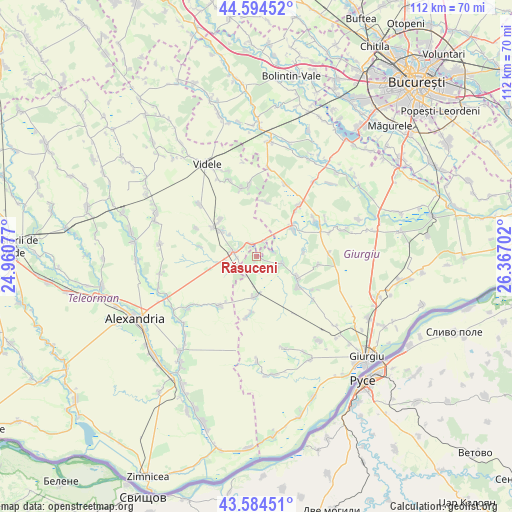
Răsuceni GPS coordinates[2]
44° 5' 30.012" North, 25° 39' 50.004" East
| Map corner | latitude | longitude |
|---|---|---|
| Upper-left | 44.59452°, | 24.96077° |
| Center: | 44.09167°, | 25.66389° |
| Lower-right: | 43.58451°, | 26.36702° |
| Map W x H: | 112.3×112.3 km | = 69.8×69.8mi |
| max Lat: | 48.23793° ⇑95.6% North |
| Răsuceni: | 44.09167° |
| min Lat: | ⇓4.4% South 43.65638° |
| min Long | Răsuceni | max Long |
| 20.31667° | 25.66389° | 29.65403° |
| W 57%⇐ | ⇒43% E |
Elevation
Elevation of Răsuceni is 71 m = 233 ft, and this is 183.9 m = 603 ft below average elevation for this country.
| Max E: |
1278 m = 4193 ft | 87% |
| Avg. | 254.9 m = 836 ft | |
| Răsuceni | 71 m = 233 ft | |
Min E: |
-2 m = -7 ft | 13% |
See also: Romania elevation on elevation.city.
Geographical zone
Răsuceni is located in North temperate zone (between Tropic of Cancer and the Arctic Circle). Distance of this Northern Tropic circle is 2296.6 km =1427 mi to South.| Distance of | km | miles | from Răsuceni |
|---|---|---|---|
| North Pole | 5104.5 | 3171.8 | to North |
| Arctic Circle | 2498.6 | 1552.6 | to North |
| Tropic Cancer | 2296.6 | 1427 | to South |
| Equator | 4902.5 | 3046.3 | to South |


Nearby cities:
15 places around Răsuceni: (largest is in red/bold)
• Botoroaga
11.4 km =7.1 mi,  303°
303°
• Bujoreni
3.7 km =2.3 mi,  318°
318°
• Chiriacu
10.2 km =6.3 mi,  116°
116°
• Comoara
12.7 km =7.9 mi,  280°
280°
• Copaciu
13.1 km =8.1 mi,  39°
39°
• Cucuruzu
5.6 km =3.5 mi,  103°
103°
• Drăgăneşti-Vlaşca
5.4 km =3.4 mi, 281°
• Izvoarele
10.9 km =6.8 mi,  125°
125°
• Letca Veche
12.1 km =7.5 mi,  8°
8°
• Naipu
10.3 km =6.4 mi,  49°
49°
• Prunaru
3.8 km =2.4 mi,  19°
19°
• Tomulești
12.9 km =8 mi,  189°
189°
• Toporu
9.1 km =5.7 mi, 185°
• Târnava
9.9 km =6.2 mi,  306°
306°
• Valea Cireșului
11.5 km =7.1 mi, 316°
Sources, notices
• [Note1] Compared only with cities in Romania existing in our database
• [Src1] Map data: © OpenStreetMap contributors (CC-BY-SA)
• [Src2] Other city data from geonames.org with taken over terms of usage.
• [Src3] Geographical zone / Annual Mean Temperature by Robert A. Rohde @ Wikipedia
