Bolvașnița geodata
Bolvașnița (Caraş-Severin) is a seat of a second-order administrative division; located in Romania in Europe/Bucharest (GMT+3) time zone. With population of 610 people, there are 6133 cities with bigger population in this country. Compared to other cities in Romania, 57.9% of cities are located further ↑North; 91.5% of cities are located further →East and 65.5% of cities have lower elevation than Bolvașnița. Note1


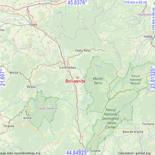
Bolvașnița GPS coordinates[2]
45° 20' 44.088" North, 22° 18' 36.432" East
| Map corner | latitude | longitude |
|---|---|---|
| Upper-left | 45.8376°, | 21.607° |
| Center: | 45.34558°, | 22.31012° |
| Lower-right: | 44.84925°, | 23.01325° |
| Map W x H: | 109.9×109.9 km | = 68.3×68.3mi |
| max Lat: | 48.23793° ⇑57.9% North |
| Bolvașnița: | 45.34558° |
| min Lat: | ⇓42.1% South 43.65638° |
| min Long | Bolvașnița | max Long |
| 20.31667° | 22.31012° | 29.65403° |
| W 8.5%⇐ | ⇒91.5% E |
Elevation
Elevation of Bolvașnița is 293 m = 961 ft, and this is 38.1 m = 125 ft above average elevation for this country.
| Max E: |
1278 m = 4193 ft | 34.5% |
| Bolvașnița | 293 m 961 ft | |
| Avg. | 254.9 m = 836 ft | |
Min E: |
-2 m = -7 ft | 65.5% |
See also: Romania elevation on elevation.city.
Geographical zone
Bolvașnița is located in North temperate zone (between Tropic of Cancer and the Arctic Circle). Distance of this North polar circle is 2359.2 km =1465.9 mi to North.| Distance of | km | miles | from Bolvașnița |
|---|---|---|---|
| North Pole | 4965.1 | 3085.2 | to North |
| Arctic Circle | 2359.2 | 1465.9 | to North |
| Tropic Cancer | 2436 | 1513.7 | to South |
| Equator | 5042 | 3133 | to South |


Nearby cities:
15 places around Bolvașnița: (largest is in red/bold)
• Borlova
4.1 km =2.5 mi,  53°
53°
• Buchin
5.3 km =3.3 mi,  296°
296°
• Bucoşniţa
6.1 km =3.8 mi,  213°
213°
• Caransebeş
10.8 km =6.7 mi,  317°
317°
• Goleț
8.1 km =5 mi, 211°
• Ilova
7.9 km =4.9 mi,  161°
161°
• Muntele Mic
4.6 km =2.9 mi,  23°
23°
• Petroșnița
4.7 km =2.9 mi,  238°
238°
• Poiana
10.3 km =6.4 mi,  274°
274°
• Slatina-Timiş
10.8 km =6.7 mi,  191°
191°
• Turnu Ruieni
5.4 km =3.4 mi, 21°
• Valea Timișului
3.5 km =2.2 mi,  276°
276°
• Vârciorova
3.9 km =2.4 mi,  122°
122°
• Vălișoara
3.5 km =2.2 mi, 209°
• Zervești
6.9 km =4.3 mi,  348°
348°
Sources, notices
• [Note1] Compared only with cities in Romania existing in our database
• [Src1] Map data: © OpenStreetMap contributors (CC-BY-SA)
• [Src2] Other city data from geonames.org with taken over terms of usage.
• [Src3] Geographical zone / Annual Mean Temperature by Robert A. Rohde @ Wikipedia
