Boghiș geodata
Boghiș (Sălaj) is a seat of a second-order administrative division; located in Romania in Europe/Bucharest (GMT+3) time zone. With population of 1,533 people, there are 3124 cities with bigger population in this country. Compared to other cities in Romania, 82.7% of cities are located further ↓South; 87.8% of cities are located further →East and 58.9% of cities have lower elevation than Boghiș. Note1


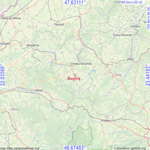
Boghiș GPS coordinates[2]
47° 9' 18.432" North, 22° 44' 19.68" East
| Map corner | latitude | longitude |
|---|---|---|
| Upper-left | 47.63111°, | 22.03568° |
| Center: | 47.15512°, | 22.7388° |
| Lower-right: | 46.67483°, | 23.44193° |
| Map W x H: | 106.3×106.3 km | = 66.1×66.1mi |
| max Lat: | 48.23793° ⇑17.3% North |
| Boghiș: | 47.15512° |
| min Lat: | ⇓82.7% South 43.65638° |
| min Long | Boghiș | max Long |
| 20.31667° | 22.7388° | 29.65403° |
| W 12.2%⇐ | ⇒87.8% E |
Elevation
Elevation of Boghiș is 257 m = 843 ft, and this is 2.1 m = 7 ft above average elevation for this country.
| Max E: |
1278 m = 4193 ft | 41.1% |
| Boghiș | 257 m 843 ft | |
| Avg. | 254.9 m = 836 ft | |
Min E: |
-2 m = -7 ft | 58.9% |
See also: Romania elevation on elevation.city.
Geographical zone
Boghiș is located in North temperate zone (between Tropic of Cancer and the Arctic Circle). Distance of this North polar circle is 2158 km =1340.9 mi to North.| Distance of | km | miles | from Boghiș |
|---|---|---|---|
| North Pole | 4763.9 | 2960.1 | to North |
| Arctic Circle | 2158 | 1340.9 | to North |
| Tropic Cancer | 2637.2 | 1638.7 | to South |
| Equator | 5243.2 | 3258 | to South |


Nearby cities:
15 places around Boghiș: (largest is in red/bold)
• Bănişor
9.4 km =5.8 mi,  127°
127°
• Drighiu
6.8 km =4.2 mi,  277°
277°
• Fizeș
6.9 km =4.3 mi,  164°
164°
• Halmăşd
9.3 km =5.8 mi,  266°
266°
• Huseni
5.8 km =3.6 mi,  57°
57°
• Iaz
5.5 km =3.4 mi,  223°
223°
• Marin
6.2 km =3.9 mi,  119°
119°
• Nuşfalău
5 km =3.1 mi,  355°
355°
• Plopiş
4.8 km =3 mi,  239°
239°
• Preoteasa
8.5 km =5.3 mi,  183°
183°
• Sâg
9.4 km =5.8 mi, 160°
• Valcău de Jos
4.3 km =2.7 mi,  185°
185°
• Valcău de Sus
4.6 km =2.9 mi, 188°
• Zăuan
9.6 km =6 mi,  323°
323°
• Şimleu Silvaniei
9.8 km =6.1 mi,  28°
28°
Sources, notices
• [Note1] Compared only with cities in Romania existing in our database
• [Src1] Map data: © OpenStreetMap contributors (CC-BY-SA)
• [Src2] Other city data from geonames.org with taken over terms of usage.
• [Src3] Geographical zone / Annual Mean Temperature by Robert A. Rohde @ Wikipedia
