Huseni geodata
Huseni (Sălaj) is a populated place; located in Romania in Europe/Bucharest (GMT+3) time zone. With population of 524 people, there are 6827 cities with bigger population in this country. Compared to other cities in Romania, 83.4% of cities are located further ↓South; 87% of cities are located further →East and 60.5% of cities have lower elevation than Huseni. Note1


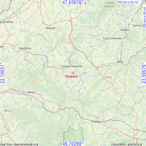
Huseni GPS coordinates[2]
47° 10' 58.872" North, 22° 48' 13.068" East
| Map corner | latitude | longitude |
|---|---|---|
| Upper-left | 47.65876°, | 22.10051° |
| Center: | 47.18302°, | 22.80363° |
| Lower-right: | 46.70298°, | 23.50676° |
| Map W x H: | 106.3×106.3 km | = 66.1×66.1mi |
| max Lat: | 48.23793° ⇑16.6% North |
| Huseni: | 47.18302° |
| min Lat: | ⇓83.4% South 43.65638° |
| min Long | Huseni | max Long |
| 20.31667° | 22.80363° | 29.65403° |
| W 13%⇐ | ⇒87% E |
Elevation
Elevation of Huseni is 266 m = 873 ft, and this is 11.1 m = 36 ft above average elevation for this country.
| Max E: |
1278 m = 4193 ft | 39.5% |
| Huseni | 266 m 873 ft | |
| Avg. | 254.9 m = 836 ft | |
Min E: |
-2 m = -7 ft | 60.5% |
See also: Romania elevation on elevation.city.
Geographical zone
Huseni is located in North temperate zone (between Tropic of Cancer and the Arctic Circle). Distance of this North polar circle is 2154.9 km =1339 mi to North.| Distance of | km | miles | from Huseni |
|---|---|---|---|
| North Pole | 4760.8 | 2958.2 | to North |
| Arctic Circle | 2154.9 | 1339 | to North |
| Tropic Cancer | 2640.3 | 1640.6 | to South |
| Equator | 5246.3 | 3259.9 | to South |


Nearby cities:
15 places around Huseni: (largest is in red/bold)
• Boghiș
5.8 km =3.6 mi,  237°
237°
• Bădăcin
9 km =5.6 mi,  25°
25°
• Bănişor
9.1 km =5.7 mi,  163°
163°
• Cehei
8.4 km =5.2 mi,  345°
345°
• Crasna
7.5 km =4.7 mi,  104°
104°
• Horoatu Crasnei
8.2 km =5.1 mi,  132°
132°
• Marin
6.2 km =3.9 mi,  175°
175°
• Nuşfalău
5.6 km =3.5 mi,  289°
289°
• Peceiu
7.9 km =4.9 mi,  145°
145°
• Pericei
8.2 km =5.1 mi,  47°
47°
• Pusta
9.2 km =5.7 mi,  319°
319°
• Valcău de Jos
9.1 km =5.7 mi,  215°
215°
• Valcău de Sus
9.4 km =5.8 mi, 216°
• Vârşolţ
10 km =6.2 mi,  79°
79°
• Şimleu Silvaniei
5.6 km =3.5 mi,  357°
357°
Sources, notices
• [Note1] Compared only with cities in Romania existing in our database
• [Src1] Map data: © OpenStreetMap contributors (CC-BY-SA)
• [Src2] Other city data from geonames.org with taken over terms of usage.
• [Src3] Geographical zone / Annual Mean Temperature by Robert A. Rohde @ Wikipedia
