Bâra geodata
Bâra (Prahova) is a populated place; located in Romania in Europe/Bucharest (GMT+3) time zone. With population of 788 people, there are 5107 cities with bigger population in this country. Compared to other cities in Romania, 78.5% of cities are located further ↑North; 67.7% of cities are located further ←West and 82.8% of cities have higher elevation than Bâra. Note1


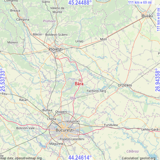
Bâra GPS coordinates[2]
44° 44' 51.612" North, 26° 14' 25.62" East
| Map corner | latitude | longitude |
|---|---|---|
| Upper-left | 45.24488°, | 25.53733° |
| Center: | 44.74767°, | 26.24045° |
| Lower-right: | 44.24614°, | 26.94358° |
| Map W x H: | 111×111 km | = 69×69mi |
| max Lat: | 48.23793° ⇑78.5% North |
| Bâra: | 44.74767° |
| min Lat: | ⇓21.5% South 43.65638° |
| min Long | Bâra | max Long |
| 20.31667° | 26.24045° | 29.65403° |
| W 67.7%⇐ | ⇒32.3% E |
Elevation
Elevation of Bâra is 85 m = 279 ft, and this is 169.9 m = 557 ft below average elevation for this country.
| Max E: |
1278 m = 4193 ft | 82.8% |
| Avg. | 254.9 m = 836 ft | |
| Bâra | 85 m = 279 ft | |
Min E: |
-2 m = -7 ft | 17.2% |
See also: Romania elevation on elevation.city.
Geographical zone
Bâra is located in North temperate zone (between Tropic of Cancer and the Arctic Circle). Distance of this Northern Tropic circle is 2369.6 km =1472.4 mi to South.| Distance of | km | miles | from Bâra |
|---|---|---|---|
| North Pole | 5031.6 | 3126.5 | to North |
| Arctic Circle | 2425.7 | 1507.3 | to North |
| Tropic Cancer | 2369.6 | 1472.4 | to South |
| Equator | 4975.5 | 3091.6 | to South |


Nearby cities:
15 places around Bâra: (largest is in red/bold)
• Balta Doamnei
5.8 km =3.6 mi,  272°
272°
• Belciug
7.9 km =4.9 mi,  4°
4°
• Curcubeu
7.8 km =4.8 mi,  282°
282°
• Gherghiţa
6.2 km =3.9 mi,  19°
19°
• Gruiu
1.7 km =1.1 mi,  199°
199°
• Lipia
4.6 km =2.9 mi,  155°
155°
• Merii Petchii
4.9 km =3 mi,  106°
106°
• Nuci
5.8 km =3.6 mi,  126°
126°
• Olari
4.5 km =2.8 mi,  336°
336°
• Olarii Vechi
5.7 km =3.5 mi,  328°
328°
• Palanca
8.2 km =5.1 mi, 337°
• Rădulești
8.9 km =5.5 mi,  76°
76°
• Siliștea Snagovului
4.9 km =3 mi,  258°
258°
• Snagov
7 km =4.3 mi,  220°
220°
• Șanțu Florești
2.7 km =1.7 mi,  228°
228°
Sources, notices
• [Note1] Compared only with cities in Romania existing in our database
• [Src1] Map data: © OpenStreetMap contributors (CC-BY-SA)
• [Src2] Other city data from geonames.org with taken over terms of usage.
• [Src3] Geographical zone / Annual Mean Temperature by Robert A. Rohde @ Wikipedia
