Biniș geodata
Biniș (Caraş-Severin) is a populated place; located in Romania in Europe/Bucharest (GMT+3) time zone. With population of 905 people, there are 4605 cities with bigger population in this country. Compared to other cities in Romania, 58% of cities are located further ↑North; 96.6% of cities are located further →East and 53.9% of cities have higher elevation than Biniș. Note1


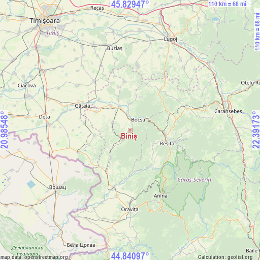
Biniș GPS coordinates[2]
45° 20' 14.568" North, 21° 41' 18.96" East
| Map corner | latitude | longitude |
|---|---|---|
| Upper-left | 45.82947°, | 20.98548° |
| Center: | 45.33738°, | 21.6886° |
| Lower-right: | 44.84097°, | 22.39173° |
| Map W x H: | 109.9×109.9 km | = 68.3×68.3mi |
| max Lat: | 48.23793° ⇑58% North |
| Biniș: | 45.33738° |
| min Lat: | ⇓42% South 43.65638° |
| min Long | Biniș | max Long |
| 20.31667° | 21.6886° | 29.65403° |
| W 3.4%⇐ | ⇒96.6% E |
Elevation
Elevation of Biniș is 192 m = 630 ft, and this is 62.9 m = 206 ft below average elevation for this country.
| Max E: |
1278 m = 4193 ft | 53.9% |
| Avg. | 254.9 m = 836 ft | |
| Biniș | 192 m = 630 ft | |
Min E: |
-2 m = -7 ft | 46.1% |
See also: Romania elevation on elevation.city.
Geographical zone
Biniș is located in North temperate zone (between Tropic of Cancer and the Arctic Circle). Distance of this North polar circle is 2360.1 km =1466.5 mi to North.| Distance of | km | miles | from Biniș |
|---|---|---|---|
| North Pole | 4966 | 3085.7 | to North |
| Arctic Circle | 2360.1 | 1466.5 | to North |
| Tropic Cancer | 2435.1 | 1513.1 | to South |
| Equator | 5041 | 3132.3 | to South |


Nearby cities:
15 places around Biniș: (largest is in red/bold)
• Berzovia
10.9 km =6.8 mi,  334°
334°
• Bocşa
4.3 km =2.7 mi,  21°
21°
• Câlnic
13.2 km =8.2 mi,  89°
89°
• Doclin
5.3 km =3.3 mi,  211°
211°
• Dognecea
8.8 km =5.5 mi,  142°
142°
• Ferendia
15.1 km =9.4 mi,  260°
260°
• Fizeș
7.9 km =4.9 mi,  292°
292°
• Forotic
14.3 km =8.9 mi, 213°
• Gherteniș
13.6 km =8.5 mi,  321°
321°
• Lupac
11.6 km =7.2 mi,  123°
123°
• Ocna de Fier
7.4 km =4.6 mi, 93°
• Rafnic
14 km =8.7 mi,  146°
146°
• Ramna
11.2 km =7 mi,  359°
359°
• Surducu Mare
11.1 km =6.9 mi,  225°
225°
• Tirol
7.2 km =4.5 mi,  265°
265°
Sources, notices
• [Note1] Compared only with cities in Romania existing in our database
• [Src1] Map data: © OpenStreetMap contributors (CC-BY-SA)
• [Src2] Other city data from geonames.org with taken over terms of usage.
• [Src3] Geographical zone / Annual Mean Temperature by Robert A. Rohde @ Wikipedia
