Câlnic geodata
Câlnic (Caraş-Severin) is a populated place; located in Romania in Europe/Bucharest (GMT+3) time zone. With population of 1,687 people, there are 2936 cities with bigger population in this country. Compared to other cities in Romania, 58% of cities are located further ↑North; 95.4% of cities are located further →East and 50.7% of cities have higher elevation than Câlnic. Note1


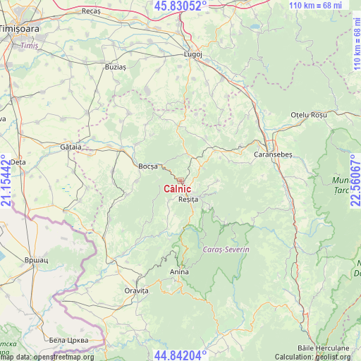
Câlnic GPS coordinates[2]
45° 20' 18.384" North, 21° 51' 27.144" East
| Map corner | latitude | longitude |
|---|---|---|
| Upper-left | 45.83052°, | 21.15442° |
| Center: | 45.33844°, | 21.85754° |
| Lower-right: | 44.84204°, | 22.56067° |
| Map W x H: | 109.9×109.9 km | = 68.3×68.3mi |
| max Lat: | 48.23793° ⇑58% North |
| Câlnic: | 45.33844° |
| min Lat: | ⇓42% South 43.65638° |
| min Long | Câlnic | max Long |
| 20.31667° | 21.85754° | 29.65403° |
| W 4.6%⇐ | ⇒95.4% E |
Elevation
Elevation of Câlnic is 208 m = 682 ft, and this is 46.9 m = 154 ft below average elevation for this country.
| Max E: |
1278 m = 4193 ft | 50.7% |
| Avg. | 254.9 m = 836 ft | |
| Câlnic | 208 m = 682 ft | |
Min E: |
-2 m = -7 ft | 49.3% |
See also: Romania elevation on elevation.city.
Geographical zone
Câlnic is located in North temperate zone (between Tropic of Cancer and the Arctic Circle). Distance of this North polar circle is 2360 km =1466.4 mi to North.| Distance of | km | miles | from Câlnic |
|---|---|---|---|
| North Pole | 4965.9 | 3085.7 | to North |
| Arctic Circle | 2360 | 1466.4 | to North |
| Tropic Cancer | 2435.2 | 1513.2 | to South |
| Equator | 5041.2 | 3132.5 | to South |


Nearby cities:
15 places around Câlnic: (largest is in red/bold)
• Biniș
13.2 km =8.2 mi,  269°
269°
• Bocşa
12.2 km =7.6 mi,  288°
288°
• Clocotici
10.5 km =6.5 mi,  189°
189°
• Dognecea
10.6 km =6.6 mi,  227°
227°
• Doman
9.3 km =5.8 mi,  150°
150°
• Ezeriş
8.3 km =5.2 mi,  15°
15°
• Lupac
7.4 km =4.6 mi,  208°
208°
• Nermed
12.1 km =7.5 mi,  177°
177°
• Ocna de Fier
5.8 km =3.6 mi,  264°
264°
• Rafnic
12.9 km =8 mi,  204°
204°
• Reşiţa
4.9 km =3 mi, 149°
• Secu
12.2 km =7.6 mi,  128°
128°
• Soceni
8 km =5 mi,  61°
61°
• Târnova
11.6 km =7.2 mi,  87°
87°
• Țerova
6.2 km =3.9 mi,  122°
122°
Sources, notices
• [Note1] Compared only with cities in Romania existing in our database
• [Src1] Map data: © OpenStreetMap contributors (CC-BY-SA)
• [Src2] Other city data from geonames.org with taken over terms of usage.
• [Src3] Geographical zone / Annual Mean Temperature by Robert A. Rohde @ Wikipedia
