Bereşti-Bistriţa geodata
Bereşti-Bistriţa (Bacău) is a seat of a second-order administrative division; located in Romania in Europe/Bucharest (GMT+3) time zone. With population of 3,377 people, there are 1504 cities with bigger population in this country. Compared to other cities in Romania, 72% of cities are located further ↓South; 79.3% of cities are located further ←West and 58.3% of cities have lower elevation than Bereşti-Bistriţa. Note1


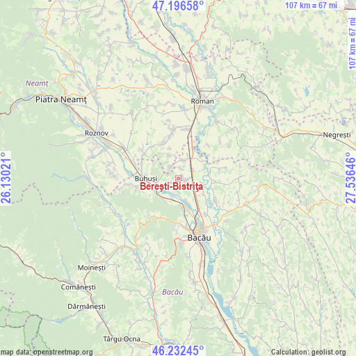
Bereşti-Bistriţa GPS coordinates[2]
46° 43' 0.012" North, 26° 49' 59.988" East
| Map corner | latitude | longitude |
|---|---|---|
| Upper-left | 47.19658°, | 26.13021° |
| Center: | 46.71667°, | 26.83333° |
| Lower-right: | 46.23245°, | 27.53646° |
| Map W x H: | 107.2×107.2 km | = 66.6×66.6mi |
| max Lat: | 48.23793° ⇑28% North |
| Bereşti-Bistriţa: | 46.71667° |
| min Lat: | ⇓72% South 43.65638° |
| min Long | Bereşti-Bistri | max Long |
| 20.31667° | 26.83333° | 29.65403° |
| W 79.3%⇐ | ⇒20.7% E |
Elevation
Elevation of Bereşti-Bistriţa is 254 m = 833 ft, and this is 0.90000000000001 m = 3 ft below average elevation for this country.
| Max E: |
1278 m = 4193 ft | 41.7% |
| Avg. | 254.9 m = 836 ft | |
| Bereşti-Bistriţa | 254 m = 833 ft | |
Min E: |
-2 m = -7 ft | 58.3% |
See also: Romania elevation on elevation.city.
Geographical zone
Bereşti-Bistriţa is located in North temperate zone (between Tropic of Cancer and the Arctic Circle). Distance of this North polar circle is 2206.8 km =1371.2 mi to North.| Distance of | km | miles | from Bereşti-Bistriţa |
|---|---|---|---|
| North Pole | 4812.7 | 2990.5 | to North |
| Arctic Circle | 2206.8 | 1371.2 | to North |
| Tropic Cancer | 2588.5 | 1608.4 | to South |
| Equator | 5194.4 | 3227.6 | to South |


Nearby cities:
15 places around Bereşti-Bistriţa: (largest is in red/bold)
• Bahna
8.3 km =5.2 mi,  332°
332°
• Buda
10 km =6.2 mi,  239°
239°
• Cârligi
5.6 km =3.5 mi,  13°
13°
• Filipeşti
5.3 km =3.3 mi,  45°
45°
• Galbeni
2.9 km =1.8 mi, 14°
• Gura Văii
4.5 km =2.8 mi,  219°
219°
• Gârleni
6.1 km =3.8 mi,  204°
204°
• Gârlenii de Sus
7.5 km =4.7 mi, 202°
• Hemeiuș
10.2 km =6.3 mi,  170°
170°
• Iteşti
7.7 km =4.8 mi,  157°
157°
• Izvoare
4.1 km =2.5 mi,  324°
324°
• Lespezi
7.6 km =4.7 mi, 220°
• Lilieci
10.2 km =6.3 mi, 163°
• Racova
6.6 km =4.1 mi,  253°
253°
• Siretu
9 km =5.6 mi,  123°
123°
Sources, notices
• [Note1] Compared only with cities in Romania existing in our database
• [Src1] Map data: © OpenStreetMap contributors (CC-BY-SA)
• [Src2] Other city data from geonames.org with taken over terms of usage.
• [Src3] Geographical zone / Annual Mean Temperature by Robert A. Rohde @ Wikipedia
