Başcov geodata
Başcov (Arges) is a seat of a second-order administrative division; located in Romania in Europe/Bucharest (GMT+3) time zone. With population of 8,759 people, there are 262 cities with bigger population in this country. Compared to other cities in Romania, 73.2% of cities are located further ↑North; 55.2% of cities are located further →East and 65.7% of cities have lower elevation than Başcov. Note1


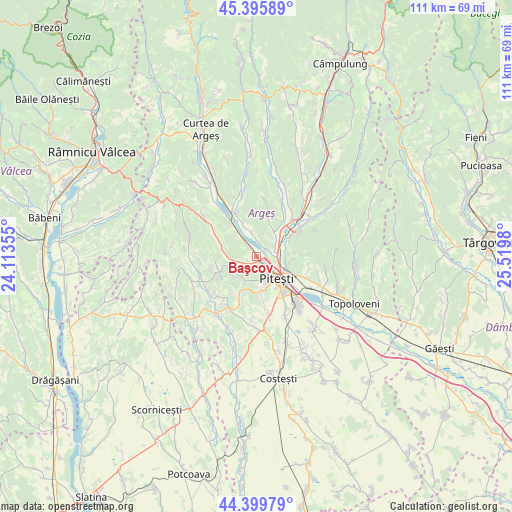
Başcov GPS coordinates[2]
44° 54' 0" North, 24° 49' 0.012" East
| Map corner | latitude | longitude |
|---|---|---|
| Upper-left | 45.39589°, | 24.11355° |
| Center: | 44.9°, | 24.81667° |
| Lower-right: | 44.39979°, | 25.5198° |
| Map W x H: | 110.8×110.8 km | = 68.8×68.8mi |
| max Lat: | 48.23793° ⇑73.2% North |
| Başcov: | 44.9° |
| min Lat: | ⇓26.8% South 43.65638° |
| min Long | Başcov | max Long |
| 20.31667° | 24.81667° | 29.65403° |
| W 44.8%⇐ | ⇒55.2% E |
Elevation
Elevation of Başcov is 294 m = 965 ft, and this is 39.1 m = 128 ft above average elevation for this country.
| Max E: |
1278 m = 4193 ft | 34.3% |
| Başcov | 294 m 965 ft | |
| Avg. | 254.9 m = 836 ft | |
Min E: |
-2 m = -7 ft | 65.7% |
See also: Romania elevation on elevation.city.
Geographical zone
Başcov is located in North temperate zone (between Tropic of Cancer and the Arctic Circle). Distance of this Northern Tropic circle is 2386.5 km =1482.9 mi to South.| Distance of | km | miles | from Başcov |
|---|---|---|---|
| North Pole | 5014.6 | 3115.9 | to North |
| Arctic Circle | 2408.8 | 1496.8 | to North |
| Tropic Cancer | 2386.5 | 1482.9 | to South |
| Equator | 4992.4 | 3102.1 | to South |


Nearby cities:
15 places around Başcov: (largest is in red/bold)
• Argeșelu
5.3 km =3.3 mi,  54°
54°
• Borlești
6.8 km =4.2 mi,  322°
322°
• Budeasa Mare
3 km =1.9 mi,  16°
16°
• Budeasa Mică
6.1 km =3.8 mi,  25°
25°
• Ciocănăi
6.5 km =4 mi,  201°
201°
• Dobrogostea
4.2 km =2.6 mi, 321°
• Glâmbocu
2 km =1.2 mi,  249°
249°
• Gălășești
6.7 km =4.2 mi,  338°
338°
• Mica
4.9 km =3 mi, 249°
• Miceşti
6.8 km =4.2 mi,  35°
35°
• Mărăcineni
5.3 km =3.3 mi,  90°
90°
• Piteşti
6.8 km =4.2 mi,  144°
144°
• Prislopu Mare
6.5 km =4 mi,  273°
273°
• Uiasca
1.9 km =1.2 mi,  163°
163°
• Valea Ursului
3.8 km =2.4 mi, 251°
Sources, notices
• [Note1] Compared only with cities in Romania existing in our database
• [Src1] Map data: © OpenStreetMap contributors (CC-BY-SA)
• [Src2] Other city data from geonames.org with taken over terms of usage.
• [Src3] Geographical zone / Annual Mean Temperature by Robert A. Rohde @ Wikipedia
